0 An Co Rd

Description
- Listed by Mike Whitworth • TREC #3_4 • COMBINED ASSOCIATESP: (903)-724-2369 whitworth477@gmail.com
Property Details for 0 An Co Road
Property Details for 0 An Co Road
| Status | Closed |
|---|---|
| MLS # | 88426 |
| Days on Market | 145 |
| Taxes | $632 / year |
| HOA Fees | - |
| Condo/Co-op Fees | - |
| Property Type | Land |
| MLS Type | Land / Unimproved Land |
| Year Built | - |
| Lot Size | 58.00 AC |
| County | Anderson County |
Location
Sold By Office outside MLS, Outside Mls Agent Outside Mls Agent, TREC #1023_1
Building Information for 0 An Co Road
Payment Calculator
$1,252 per month
30 year fixed, 6.36% Interest
$1,199
$53
$0
Know your buying power with a preapproval and custom rate in minutes
 1
1Property Information for 0 An Co Road
- MLS Area Major: Hwy 19N-FM 315
- Parcel Number: R844217/14651
- Tax Annual Amount: $632.44
- Tax Legal Description: +or - 58 acres to be surveyed from A0034 Kimbrough, William, Block 1281, Tract 1A, &1A2 Block 1279, Tract 1B, as recorded in the Anderson County Record of Deed, Volume 1961, Page 550 and Vol. 2489, Page 772. Out of +or-124.615 acres.
- Elementary School District: Palestine ISD
- High School District: Palestine ISD
- Middle Or Junior School District: Palestine ISD
- Attached Garage: No
- Lot Features: Level, Sloped
- Lot Size Acres: 58.0
- Lot Size Area: 58.0
- Lot Size Square Feet: 2526480.0
- Lot Size Units: Acres
- Topography: Level,Sloping
- Current Use: Recreational, Vacant
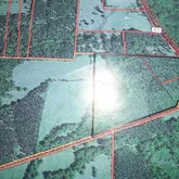
- Documents Available: Survey/Plat, ACAD Map, Aerial Photo
- Possible Use: Residential, Recreational
- Property Sub Type: Unimproved Land
- Property Type: Land
- Electric On Property: Yes
- Utilities: Phone Available, Electricity Available, Water Connected
- Fencing: Barbed Wire
Property History for 0 An Co Road
| Date | Event & Source | Price | Appreciation |
|---|---|---|---|
| Jun 8, 2018 | Sold Palestine Association of REALTORS #88426 | — | |
| Jan 17, 2018 | Listed (Active) Palestine Association of REALTORS #88426 | $240,700 | — |
| Date | Event & Source | Price |
|---|---|---|
| 06/08/2018 | Sold Palestine Association of REALTORS #88426 | — |
| 01/17/2018 | Listed (Active) Palestine Association of REALTORS #88426 | $240,700 |
For completeness, we often displays two records for one sale: the MLS record and the public record.
Schools near 0 An Co Road
Rating | School | Type | Grades | Distance |
|---|---|---|---|---|
| Public - | PK to 2 | |||
| Public - | 3 to 6 | |||
| Public - | 7 to 8 | |||
| Public - | 9 to 12 |
Rating | School | Distance |
|---|---|---|
Westwood Primary School PublicPK to 2 | ||
Westwood Elementary School Public3 to 6 | ||
Westwood Junior High School Public7 to 8 | ||
Westwood High School Public9 to 12 |
School ratings and boundaries are provided by GreatSchools.org and Pitney Bowes. This information should only be used as a reference. Proximity or boundaries shown here are not a guarantee of enrollment. Please reach out to schools directly to verify all information and enrollment eligibility.
Similar Homes
Explore Nearby Homes
- Poynor Homes for Sale
- Safari Waters Ranch Homes for Sale
- Berryville Homes for Sale
- Oakwood - Leon County Homes for Sale
- Coffee City Homes for Sale
- Shadybrook Homes for Sale
- Moore Station Homes for Sale
- Cumberland Ridge Homes for Sale
- Lakeway Harbor Homes for Sale
- Cedar Bay Homes for Sale
- Sunrise Shores Homes for Sale
- Emerald Bay Homes for Sale
- Oakwood Homes for Sale
- Pine Trail Shores Homes for Sale
- Pecan Valley Ranch Homes for Sale
- Tennessee Colony Homes for Sale
- Palestine Homes for Sale
- Oakwood Homes for Sale
- Neches Homes for Sale
- Montalba Homes for Sale
- Larue Homes for Sale
- Frankston Homes for Sale
- Cuney Homes for Sale
- Jacksonville Homes for Sale
- Elkhart Homes for Sale
- Flint Homes for Sale
- Athens Homes for Sale
- Bullard Homes for Sale
- Murchison Homes for Sale
- Fairfield Homes for Sale
- 75770 Homes for Sale
- 75752 Homes for Sale
- 75763 Homes for Sale
- 75861 Homes for Sale
- 75855 Homes for Sale
- 75853 Homes for Sale
- 75801 Homes for Sale
- 75779 Homes for Sale
- 75766 Homes for Sale
- 75886 Homes for Sale
- 75840 Homes for Sale
- 75751 Homes for Sale
- 75759 Homes for Sale
- 75839 Homes for Sale
- 75757 Homes for Sale
No guarantee, warranty or representation of any kind is made regarding the completeness or accuracy of any information, descriptions or measurements (including square footage measurements and property condition), such should be independently verified through appropriate means, including, but not limited to, in person inspection and public records, and Compass International Holdings, its subsidiaries, affiliates and independently owned and operated franchisees, and their affiliated agents and associated third parties expressly disclaim any liability in connection therewith. Photos may be virtually staged or digitally enhanced and may not reflect actual property conditions. Offers of compensation are subject to change at the seller's discretion. No financial or legal advice provided. Equal Housing Opportunity. Subject to change at any time. Compass, Inc., its subsidiaries, affiliates and their agents and associated third parties make no guarantee, warranty or representation regarding the accuracy of any waterfront feature, water view or waterfront view.
Listing Courtesy of COMBINED ASSOCIATES, Mike Whitworth, TREC #3_4
IDX information is provided exclusively for consumers' personal, non-commercial use, that it may not be used for any purpose other than to identify prospective properties consumers may be interested in purchasing. Information deemed to be reliable but not guaranteed.