


Description
- Listed by Amanda Greenwood • Century 21 Community
Property Details for 12-acres Landing Trail
Property Details for 12-acres Landing Trail
| Status | Active |
|---|---|
| MLS # | 25048635 |
| Days on Market | 153 |
| Taxes | $1 / year |
| HOA Fees | - |
| Condo/Co-op Fees | - |
| Compass Type | Land |
| MLS Type | Land |
| Year Built | - |
| Lot Size | - |
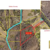
| County | Dallas County |
Location
Payment Calculator
$890 per month
30 year fixed, 6.28% Interest
$889
$0
$0
Property Information for 12-acres Landing Trail
- City: Lebanon
- County Or Parish: Laclede
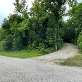
- Directions: From Hwy 64 to AA to WW. Take a right on Maine Dr, left on Industrial, and Right on Marigold. Follow Marigold until you see Landing Trail on the right. Gated Community. Need gate code to access. Go to Property with small Camper at the road...wooded acreage is right across from it, and river access will be at the edge of the camper's property
- Latitude: 37.80263305
- Longitude: -92.8614027
- Postal Code: 65536
- State Or Province: MO
- Sub division Name: Rural
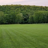
- Topography: High Ground ,Sloping
- List AOR: Pulaski County Board of REALTORS
- Parcel Number: 05-3.0-06-000-000-003.002
- Tax Annual Amount: $1.00
- Tax Year: 2024
- Township: Lebanon
- Elementary School: Long Lane Elem.
- High School: Buffalo High
- High School District: Dallas Co. R-I
- Middle Or Junior School: Buffalo Middle
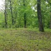
- Lot Features: Heavy Woods, Many Trees, Rolling Slope, Sloped, Sloped Down
- Lot Size Acres: 12.0
- Lot Size Source: Other
- Property Type: Land
- Documents Available: None Available
- Documents Count: 0
- Photos Count: 6
- Disclosures: None
- Ownership Type: Private
- Electric: Other
- Sewer: None
- Utilities: Electricity Available
- Water Source: None
- Bathrooms Full: 0
- Bathrooms Half: 0
- Bedrooms Total: 0
Property History for 12-acres Landing Trail
| Date | Event & Source | Price | Appreciation |
|---|---|---|---|
| Jul 14, 2025 | Listed (Active) MARIS #25048635 | $180,000 | — |
| Date | Event & Source | Price |
|---|---|---|
| 07/14/2025 | Listed (Active) MARIS #25048635 | $180,000 |
For completeness, Compass often displays two records for one sale: the MLS record and the public record.
Schools near 12-acres Landing Trail
Rating | School | Type | Grades | Distance |
|---|---|---|---|---|
| Public - | PK to 4 | |||
| Public - | 5 to 8 | |||
| Public - | 9 to 12 | |||
| Public - | 11 to 12 |
Rating | School | Distance |
|---|---|---|
Mallory Elementary School PublicPK to 4 | ||
Buffalo Middle School Public5 to 8 | ||
Buffalo High School Public9 to 12 | ||
Dallas County Career Center Public11 to 12 |
School ratings and boundaries are provided by GreatSchools.org and Pitney Bowes. This information should only be used as a reference. Proximity or boundaries shown here are not a guarantee of enrollment. Please reach out to schools directly to verify all information and enrollment eligibility.
Similar Homes
Similar Sold Homes
Explore Nearby Homes
- Auglaize Township - Camden County Homes for Sale
- Wilson Township - Dallas County Homes for Sale
- Washington Township - Laclede County Homes for Sale
- Warren Township - Camden County Homes for Sale
- Union Township - Laclede County Homes for Sale
- Spring Hollow Township - Laclede County Homes for Sale
- Phillipsburg Township - Laclede County Homes for Sale
- Osage Township - Laclede County Homes for Sale
- Miller Township - Dallas County Homes for Sale
- May/Smith Township - Laclede County Homes for Sale
- Lebanon Township - Laclede County Homes for Sale
- Jasper Township - Dallas County Homes for Sale
- Franklin Township - Laclede County Homes for Sale
- Evergreen Homes for Sale
- Eldridge Township - Laclede County Homes for Sale
- Windyville Homes for Sale
- Long Lane Homes for Sale
- Lebanon Homes for Sale
- Eldridge Homes for Sale
- Stoutland Homes for Sale
- Phillipsburg Homes for Sale
- Falcon Homes for Sale
- Montreal Homes for Sale
- Tunas Homes for Sale
- Elkland Homes for Sale
- Laquey Homes for Sale
- Camdenton Homes for Sale
- Conway Homes for Sale
- Grovespring Homes for Sale
- Linn Creek Homes for Sale
- 65764 Homes for Sale
- 65722 Homes for Sale
- 65662 Homes for Sale
- 65632 Homes for Sale
- 65591 Homes for Sale
- 65590 Homes for Sale
- 65567 Homes for Sale
- 65556 Homes for Sale
- 65470 Homes for Sale
- 65463 Homes for Sale
- 65020 Homes for Sale
- 65783 Homes for Sale
- 65622 Homes for Sale
- 65711 Homes for Sale
- 65713 Homes for Sale
No guarantee, warranty or representation of any kind is made regarding the completeness or accuracy of descriptions or measurements (including square footage measurements and property condition), such should be independently verified, and Compass expressly disclaims any liability in connection therewith. Photos may be virtually staged or digitally enhanced and may not reflect actual property conditions. Offers of compensation are subject to change at the discretion of the seller. No financial or legal advice provided. Equal Housing Opportunity. Subject to change at any time. Compass makes no guarantee, warranty or representation regarding the accuracy of any waterfront feature, water view or waterfront view.
Listing Courtesy of Century 21 Community
Properties displayed may be listed or sold by various participants in the MLS. Based on information submitted to the MLS GRID as of 12/15/2025 01:44 PM. All data is obtained from various sources and may not have been verified by broker orMLS GRID. Supplied Open House Information is subject to change without notice. All informationshould be independently reviewed and verified for accuracy. Properties may or may not be listed bythe office/agent presenting the information.