35 T21n R27e


Description
- Listed by Carl Wilkins • Forest Properties - St. JohnsP: (928)-551-3871 C: (928)-551-3871 cwilkins8fp@gmail.com
Property Details for 35 T21n R27e
Property Details for 35 T21n R27e
| Status | Closed |
|---|---|
| MLS # | 227608 |
| Days on Market | 227 |
| Taxes | $94 / year |
| HOA Fees | - |
| Condo/Co-op Fees | - |
| Property Type | Land |
| MLS Type | Land / Agriculture |
| Year Built | - |
| Lot Size | 75.61 AC |
| County | Apache County |
Location
Sold By Forest Properties - St. Johns; Forest Properties Inc - Show Low
Building Information for 35 T21n R27e
Payment Calculator
$134 per month
30 year fixed, 6.46% Interest
$126
$8
$0
Know your buying power with a preapproval and custom rate in minutes
 1
1Property Information for 35 T21n R27e
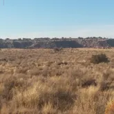
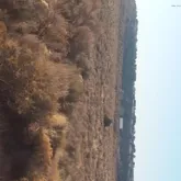
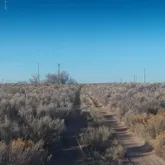
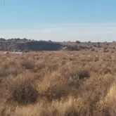
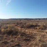
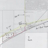
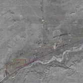
- Directions: From exit 333 on I-40 take the south frontage road down the hill to the west till pavement ends, follow the 2 track Rd south then west for a total of approx 7/10 mile to approx the SE corner of parcel 001A. Approx GPS @ this point is: 35.182922, -109.448168.
- MLS Area Major: Sanders
- MLS Area Minor: Sanders
- Township: 21N
- Additional Parcels Description: No
- Association Name: No
- Parcel Number: 207-16-001A
- Tax Annual Amount: $94.16
- Tax Legal Description: SECTION 35 TOWNSHIP 21 NORTH RANGE 27 EAST THE PT LYING BTWN HWY AND RR.
- Tax Tract: 35
- High School District: Sanders
- Lot Features: Level, Sloped, Rolling Slope, Cul-De-Sac
- Lot Size Acres: 75.61
- Lot Size Area: 75.61
- Lot Size Square Feet: 3293572.0
- Lot Size Units: Acres
- Public Survey Range: 27E
- Road Responsibility: Public Maintained Road, Private Maintained Road
- Documents Available: Legal Description
- Possible Use: Horses
- Property Sub Type: Agriculture
- Property Type: Land
- Horse: Yes
- Utilities: Electricity Available
- Fencing: Partial, Wire
- New Taxes Expense: $2,019.00
- Mobile Home Remains: Yes
Property History for 35 T21n R27e
| Date | Event & Source | Price | Appreciation |
|---|---|---|---|
| Jun 29, 2020 | Sold White Mountain Association of REALTORS #227608 | $25,000 | — |
| May 28, 2020 | Pending White Mountain Association of REALTORS #227608 | — | |
| Nov 19, 2019 | Listed (Active) White Mountain Association of REALTORS #227608 | $29,900 | — |
| Date | Event & Source | Price |
|---|---|---|
| 06/29/2020 | Sold White Mountain Association of REALTORS #227608 | $25,000 |
| 05/28/2020 | Pending White Mountain Association of REALTORS #227608 | — |
| 11/19/2019 | Listed (Active) White Mountain Association of REALTORS #227608 | $29,900 |
For completeness, Compass often displays two records for one sale: the MLS record and the public record.
Schools near 35 T21n R27e
Rating | School | Type | Grades | Distance |
|---|---|---|---|---|
| Public - | PK to 7 | |||
| Public - | 6 to 8 | |||
| Public - | 9 to 12 | |||
| Public - | K to 12 |
Rating | School | Distance |
|---|---|---|
Sanders Elementary School PublicPK to 7 | ||
Sanders Middle School Public6 to 8 | ||
Valley High School Public9 to 12 | ||
Lichii' Deezh'ahi Learning Academy PublicK to 12 |
School ratings and boundaries are provided by GreatSchools.org and Pitney Bowes. This information should only be used as a reference. Proximity or boundaries shown here are not a guarantee of enrollment. Please reach out to schools directly to verify all information and enrollment eligibility.
Similar Homes
Explore Nearby Homes
- Klagetoh Homes for Sale
- Wide Ruins Homes for Sale
- Oak Springs Homes for Sale
- Greasewood Homes for Sale
- Cornfields Homes for Sale
- Manuelito Homes for Sale
- Burnside Homes for Sale
- Tse Bonito Homes for Sale
- Black Hat Homes for Sale
- Purty Rock Homes for Sale
- Whitecone Homes for Sale
- Williams Acres Homes for Sale
- Crestview Homes for Sale
- Steamboat Homes for Sale
- Sawmill Homes for Sale
- Sanders Homes for Sale
- Petrified Forest National Park Homes for Sale
- Houck Homes for Sale
- Chambers Homes for Sale
- Sun Valley Homes for Sale
- Ganado Homes for Sale
- Lupton Homes for Sale
- St. Michaels Homes for Sale
- Woodruff Homes for Sale
- Window Rock Homes for Sale
- Indian Wells Homes for Sale
- Fort Defiance Homes for Sale
- Holbrook Homes for Sale
- St. Johns Homes for Sale
- Heber Homes for Sale
- 86028 Homes for Sale
- 85924 Homes for Sale
- 85936 Homes for Sale
- 86512 Homes for Sale
- 86511 Homes for Sale
- 86506 Homes for Sale
- 86505 Homes for Sale
- 86025 Homes for Sale
- 86031 Homes for Sale
- 86508 Homes for Sale
- 86029 Homes for Sale
- 85937 Homes for Sale
- 85942 Homes for Sale
- 87301 Homes for Sale
- 87326 Homes for Sale
No guarantee, warranty or representation of any kind is made regarding the completeness or accuracy of descriptions or measurements (including square footage measurements and property condition), such should be independently verified, and Compass, Inc., its subsidiaries, affiliates and their agents and associated third parties expressly disclaims any liability in connection therewith. Photos may be virtually staged or digitally enhanced and may not reflect actual property conditions. Offers of compensation are subject to change at the discretion of the seller. No financial or legal advice provided. Equal Housing Opportunity.
Listing Courtesy of Forest Properties - St. Johns
The data relating to real estate for sale on this website comes in part from the Internet Data exchange program of the White Mountain Association of REALTORS®. IDX information is provided exclusively for consumers' personal, non-commercial use and may not be used for any purpose other than to identify prospective properties consumers may be interested in purchasing. Real estate listings held by brokerage firms other than Compass and its related brokerages, are indicated by detailed information about them such as the name of the listing firms. Information deemed reliable but not guaranteed. Copyright © 2026 White Mountain Association of REALTORS®. All Rights Reserved.
