

Description
- Listed by Selena Lovejoy • Brokerage DRE #24143 • The Lovejoy Group LLCP: (601)-278-3617 C: (601)-278-3617 selenalovejoy@gmail.com
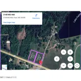
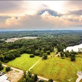
Property Details for 3550 Highway 468
Property Details for 3550 Highway 468
| Status | Active |
|---|---|
| MLS # | 4129223 |
| Days on Market | 118 |
| Taxes | - |
| HOA Fees | - |
| Condo/Co-op Fees | - |
| Compass Type | Land |
| MLS Type | Land / Unimproved Commercial Lot for Sale |
| Year Built | - |
| Lot Size | 1.13 AC |
| County | Rankin County |
Location
Building Information for 3550 Highway 468
Payment Calculator
$1,218 per month
30 year fixed, 6.15% Interest
$1,218
$0
$0
Know your buying power with a preapproval and custom rate in minutes
 1
1Property Information for 3550 Highway 468
- Community Features: None
- Fencing: None
- Subdivision Name: Metes And Bounds
- Latitude: 32.24
- Longitude: -90.10
- Association Fee: $0
- Tax Legal Description: A tract or parcel of land containing 1.13 acres, more or less, lying and being situated in the Southwest 1/4 of the Southwest 1/4 of Section 28, Township 5 North, Range 2 East, Rankin County, Mississippi and being more particularly described by metes and bounds as follows: Commencing at a fence corner marking the Northeast corner of the Southeast 1/4 of the Southwest 1/4 of said Section 28; run thence South 76 degrees 50 minutes 54 seconds West for a distance of 1261.10 feet to a set 1/2 iron pin; thence North 78 degrees 45 minutes 15 seconds West for a distance of 145.08 feet to a set 1/2 iron pin marking the Point of Beginning of the herein described property; thence South 21 degrees 32 minutes 04 seconds West for a distance of 293.45 feet to a set 1/2 inch iron pin marking the North Right-of-Way of Whitfield Road (State Highway 468); thence North 68 degrees 27 minutes 56 seconds West along said North Right of Way of Whitfield Road (State Highway 468) for a distance of 177.00 feet to a set 1/2 inch iron pin; thence North 21 degrees 32 minutes 04 seconds East for a distance of 261.32 feet to a set 1/2 inch iron pin; thence South 78 degrees 45 minutes 15 seconds East for a distance of 179.89 feet to the Point of Beginning.
- Tax Year: 2025
- Tax Annual Amount: $.00
- Tax and Financial Information:Tax Annual Amount: $.00
- Tax and Financial Information:Tax Year: 2,025.00
- Tax and Financial Information:Homestead Y/N: No
- Tax and Financial Information:Additional Exemptions Y/N: No
- Tax and Financial Information:Flood Insurance Required?: No
- Tax and Financial Information:Leasehold Y/N: No
- Tax and Financial Information:Association: No
- Tax and Financial Information:Covenants Y/N: No
- Tax and Financial Information:Legal Description: A tract or parcel of land containing 1.13 acres, more or less, lying and being situated in the Southwest 1/4 of the Southwest 1/4 of Section 28, Township 5 North, Range 2 East, Rankin County, Mississippi and being more particularly described by metes and bounds as follows: Commencing at a fence corner marking the Northeast corner of the Southeast 1/4 of the Southwest 1/4 of said Section 28; run thence South 76 degrees 50 minutes 54 seconds West for a distance of 1261.10 feet to a set 1/2 iron pin; thence North 78 degrees 45 minutes 15 seconds West for a distance of 145.08 feet to a set 1/2 iron pin marking the Point of Beginning of the herein described property; thence South 21 degrees 32 minutes 04 seconds West for a distance of 293.45 feet to a set 1/2 inch iron pin marking the North Right-of-Way of Whitfield Road (State Highway 468); thence North 68 degrees 27 minutes 56 seconds West along said North Right of Way of Whitfield Road (State Highway 468) for a distance of 177.00 feet to a set 1/2 inch iron pin; thence North 21 degrees 32 minutes 04 seconds East for a distance of 261.32 feet to a set 1/2 inch iron pin; thence South 78 degrees 45 minutes 15 seconds East for a distance of 179.89 feet to the Point of Beginning.
- Elementary School: Pearl Lower
- High School: Pearl
- Middle Or Junior School: Pearl
- District High School: Pearl Public
- Other Structures: None
- Lot Size Acres: 1.13
- Lot Features: City Lot, Level
- Lot Size Area: 1.13
- Lot Size Units: Acres
- Lot Size Square Feet: 49222.8
- Land Details:Acres Pasture: 113
- Waterfront Features:Waterfront: No
- Waterfront Features:None: Yes
- New Construction: No
- Disclosures: None
- Floor Plans Count: 0
- Property Type: Land
- Property Sub Type: Unimproved Commercial Lot for Sale
- Current Use: Agricultural
- Possible Use: Commercial
- Road Frontage Type: Highway
- Road Surface Type: Asphalt
- General Property Information:Property Sub Type: Unimproved Commercial Lot for Sale
- General Property Information:New Construction: No
- General Property Information:Approx Lot Size Acres: 1.13
- General Property Information:Expandable Area: Yes
- General Property Information:Number of Lots: 1.00
- General Property Information:Divisible: No
- General Property Information:School District: Pearl Public
- General Property Information:Elementary School: Pearl Lower
- General Property Information:Elementary School 2: Pearl Upper
- General Property Information:Middle or Junior School: Pearl
- General Property Information:High School: Pearl
- Utilities: Electricity Available, Sewer Available, Water Available
- Exterior Features: None
- Horse Amenities: None
- Workshop Features:Workshop Features Workshop: No
- Horse Amenities:Horse Amenities: No
- Horse Amenities:None: Yes
- Sewer: None
- Water Source: Public
- Bathrooms Total Integer: 0
- Bathrooms Total Decimal: .00
- Bathrooms Total Notational: .00
Property History for 3550 Highway 468
| Date | Event & Source | Price | Appreciation |
|---|---|---|---|
| Jan 27, 2026 | Listed (Active) GCAOR MLS #4129223 | $250,000 | — |
| Jan 16, 2026 | Contract Signed GCAOR MLS #4129223 | — | |
| Oct 21, 2025 | Listed (Active) GCAOR MLS #4129223 | $250,000 | — |
| Date | Event & Source | Price |
|---|---|---|
| 01/27/2026 | Listed (Active) GCAOR MLS #4129223 | $250,000 |
| 01/16/2026 | Contract Signed GCAOR MLS #4129223 | — |
| 10/21/2025 | Listed (Active) GCAOR MLS #4129223 | $250,000 |
For completeness, Compass often displays two records for one sale: the MLS record and the public record.
Schools near 3550 Highway 468
Rating | School | Type | Grades | Distance |
|---|---|---|---|---|
| Public - | PK to 1 | |||
| Public - | 2 to 3 | |||
| Public - | 4 to 5 | |||
| Public - | 6 to 8 |
Rating | School | Distance |
|---|---|---|
Rouse Elementary School PublicPK to 1 | ||
Stonebridge Elementary School Public2 to 3 | ||
Brandon Elementary School Public4 to 5 | ||
Brandon Middle School Public6 to 8 |
School ratings and boundaries are provided by GreatSchools.org and Pitney Bowes. This information should only be used as a reference. Proximity or boundaries shown here are not a guarantee of enrollment. Please reach out to schools directly to verify all information and enrollment eligibility.
Similar Homes
Similar Sold Homes
Explore Nearby Homes
- Country Place Homes for Sale
- Patrick Farms Homes for Sale
- Crossgates Homes for Sale
- Central Jackson Homes for Sale
- South Jackson Homes for Sale
- Eastgate of Crossgates Homes for Sale
- Downtown Jackson Homes for Sale
- North East Jackson Homes for Sale
- Smith Park Architectural District Homes for Sale
- Barnett Bend Homes for Sale
- Belhaven Heights Homes for Sale
- Belhaven Homes for Sale
- Robinhood Homes for Sale
- Farish Street Homes for Sale
- Cleary Homes for Sale
- Jackson Homes for Sale
- Flowood Homes for Sale
- Brandon Homes for Sale
- Florence Homes for Sale
- Whitfield Homes for Sale
- Richland Homes for Sale
- Pearl Homes for Sale
- Ridgeland Homes for Sale
- Byram Homes for Sale
- Tougaloo Homes for Sale
- Madison Homes for Sale
- Clinton Homes for Sale
- Pelahatchie Homes for Sale
- Terry Homes for Sale
- Harrisville Homes for Sale
- 39298 Homes for Sale
- 39288 Homes for Sale
- 39042 Homes for Sale
- 39073 Homes for Sale
- 39193 Homes for Sale
- 39218 Homes for Sale
- 39232 Homes for Sale
- 39201 Homes for Sale
- 39202 Homes for Sale
- 39047 Homes for Sale
- 39204 Homes for Sale
- 39216 Homes for Sale
- 39203 Homes for Sale
- 39269 Homes for Sale
- 39211 Homes for Sale
No guarantee, warranty or representation of any kind is made regarding the completeness or accuracy of descriptions or measurements (including square footage measurements and property condition), such should be independently verified, and Compass, Inc., its subsidiaries, affiliates and their agents and associated third parties expressly disclaims any liability in connection therewith. Photos may be virtually staged or digitally enhanced and may not reflect actual property conditions. Offers of compensation are subject to change at the discretion of the seller. No financial or legal advice provided. Equal Housing Opportunity.
Listing Courtesy of The Lovejoy Group LLC
The data relating to real estate listings on this website comes in part from the Internet Data Exchange (IDX) program of Multiple Listing Service of ROAM MLS, Gulf Coast Association of REALTORS, REALTOR Association of Acadiana and South West Louisiana Association of REALTORS. IDX information is provided exclusively for consumers' personal, non-commercial use and may not be used for any purpose other than to identify prospective properties consumers may be interested in purchasing. Listings provided by brokerages other than Compass are identified with the ROAM MLS, Gulf Coast Association of REALTORS, REALTOR Association of Acadiana and South West Louisiana Association of REALTORS Logos. All Information Is Deemed Reliable But Is Not Guaranteed Accurate. All information should be verified by the recipient and none is guaranteed as accurate by ROAM MLS, Gulf Coast, REALTOR Association of Acadiana and South West Louisiana Association of REALTORS.Listing information Copyright© 2026 MLS of ROAM, Gulf Coast, REALTOR Association of Acadiana and South West Louisiana Multiple Listing Service, Inc. All Rights Reserved.