


Description
- Listed by Anthony W Sheffield • Ashman-Mollere Realty, Inc.P: (228)-493-9695 C: (228)-493-9695 sheffieldanthony@aol.com
- Listed by Kameron J Breland • Ashman-Mollere Realty, Inc.P: (228)-216-5141 kameronbreland@gmail.com
Property Details for 4 Disalvo Drive
Property Details for 4 Disalvo Drive
| Status | Active |
|---|---|
| MLS # | 4135094 |
| Days on Market | 23 |
| Taxes | - |
| HOA Fees | - |
| Condo/Co-op Fees | - |
| Compass Type | Land |
| MLS Type | Land / Acreage (10 acres or less) |
| Year Built | - |
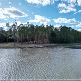
| Lot Size | 7.57 AC |
| County | Hancock County |
Location
Building Information for 4 Disalvo Drive
Payment Calculator
$970 per month
30 year fixed, 6.15% Interest
$970
$0
$0
Property Information for 4 Disalvo Drive
- Latitude: 30.48
- Longitude: -89.42
- Association Fee: $0
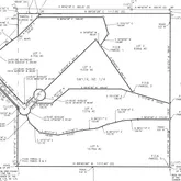
- Tax Legal Description: A PARCEL OF LAND SITUATED IN THE SOUTHWEST ¼ OF THE NORTHEAST ¼ OF SECTION 32, TOWNSHIP 6 SOUTH, RANGE 14 WEST, HANCOCK COUNTY, MISSISSIPPI, BEING MORE PARTICULARLY DESCRIBED AS FOLLOWS: COMMENCING AT AN IRON PIPE FOUND AT THE SOUTHEAST CORNER OF THE SOUTHWEST ¼ OF THE NORTHEAST ¼ OF SECTION 32; THENCE ALONG THE EAST LINE OF SAID SOUTHWEST ¼ OF THE NORTHEAST ¼ OF SECTION 32, N00°12′51″E 409.05′ TO THE POINT OF BEGINNING; THENCE N89°45′46″W 272.60′ TO A POINT; THENCE S86°11′37″W 126.75′ TO A POINT; THENCE S75°59′14″W 142.70′ TO A POINT; THENCE S68°12′37″W 103.75′ TO A POINT; THENCE S84°15′11″W 122.95′ TO A POINT; THENCE S78°31′08″W 215.00′ TO A POINT; THENCE N82°17′15″W 156.95′ TO A POINT; THENCE N47°47′15″W 211.10′ TO A POINT; THENCE N21°37′16″W 76.75′ TO A POINT ON THE EAST MARGIN OF DESALVO DRIVE; THENCE ALONG A CURVE TO THE LEFT OF SAID EAST MARGIN, HAVING AN ARC LENGTH OF 74.00′ AND A RADIUS OF 50.00′, TO A POINT BEING N27°59′56″E 67.40′; THENCE FURTHER ALONG SAID EAST MARGIN OF DESALVO DRIVE, N45°36′39″E 59.85′ TO A POINT; THENCE S89°45′46″E 144.70′ TO A POINT; THENCE N50°17′30″E 197.10′ TO A POINT; THENCE S89°45′46″E 444.60′ TO A POINT; THENCE S73°13′36″E 444.60′ TO A POINT ON THE EAST LINE OF THE SOUTHWEST ¼ OF THE NORTHEAST ¼ OF SECTION 32; THENCE ALONG SAID EAST LINE, S00°12′51″W 136.00′ TO THE POINT OF BEGINNING. SAID PARCEL CONTAINING 7.57 ACRES, MORE OR LESS.
- Tax Year: 0
- Tax Annual Amount: $.00
- Tax and Financial Information:Tax Annual Amount: $.00
- Tax and Financial Information:Tax Year: .00
- Tax and Financial Information:Homestead Y/N: No
- Tax and Financial Information:Additional Exemptions Y/N: No
- Tax and Financial Information:Flood Insurance Required?: No
- Tax and Financial Information:Leasehold Y/N: No
- Tax and Financial Information:Association: No
- Tax and Financial Information:Covenants Y/N: Yes
- Tax and Financial Information:Legal Description: A PARCEL OF LAND SITUATED IN THE SOUTHWEST ¼ OF THE NORTHEAST ¼ OF SECTION 32, TOWNSHIP 6 SOUTH, RANGE 14 WEST, HANCOCK COUNTY, MISSISSIPPI, BEING MORE PARTICULARLY DESCRIBED AS FOLLOWS: COMMENCING AT AN IRON PIPE FOUND AT THE SOUTHEAST CORNER OF THE SOUTHWEST ¼ OF THE NORTHEAST ¼ OF SECTION 32; THENCE ALONG THE EAST LINE OF SAID SOUTHWEST ¼ OF THE NORTHEAST ¼ OF SECTION 32, N00°12′51″E 409.05′ TO THE POINT OF BEGINNING; THENCE N89°45′46″W 272.60′ TO A POINT; THENCE S86°11′37″W 126.75′ TO A POINT; THENCE S75°59′14″W 142.70′ TO A POINT; THENCE S68°12′37″W 103.75′ TO A POINT; THENCE S84°15′11″W 122.95′ TO A POINT; THENCE S78°31′08″W 215.00′ TO A POINT; THENCE N82°17′15″W 156.95′ TO A POINT; THENCE N47°47′15″W 211.10′ TO A POINT; THENCE N21°37′16″W 76.75′ TO A POINT ON THE EAST MARGIN OF DESALVO DRIVE; THENCE ALONG A CURVE TO THE LEFT OF SAID EAST MARGIN, HAVING AN ARC LENGTH OF 74.00′ AND A RADIUS OF 50.00′, TO A POINT BEING N27°59′56″E 67.40′; THENCE FURTHER ALONG SAID EAST MARGIN OF DESALVO DRIVE, N45°36′39″E 59.85′ TO A POINT; THENCE S89°45′46″E 144.70′ TO A POINT; THENCE N50°17′30″E 197.10′ TO A POINT; THENCE S89°45′46″E 444.60′ TO A POINT; THENCE S73°13′36″E 444.60′ TO A POINT ON THE EAST LINE OF THE SOUTHWEST ¼ OF THE NORTHEAST ¼ OF SECTION 32; THENCE ALONG SAID EAST LINE, S00°12′51″W 136.00′ TO THE POINT OF BEGINNING. SAID PARCEL CONTAINING 7.57 ACRES, MORE OR LESS.
- Virtual Tour URL Unbranded: https://www.propertypanorama.com/Lot-4-Disalvo-Drive-Kiln-MS-39556/unbranded
- Lot Size Acres: 7.57
- Lot Size Dimensions: 7.57
- Lot Features: Many Trees, Views, Hilly
- Lot Size Area: 7.57
- Lot Size Units: Acres
- Lot Size Square Feet: 329749.2
- Land Details:Acres Wooded: 757
- Land Details:Legally Subdivided: Yes
- Land Details:Mobile Homes Allowed: No
- Waterfront Features:Waterfront: Yes
- Waterfront Features:Lake: Yes
- Floor Plans Count: 0
- Property Type: Land
- Property Sub Type: Acreage (10 acres or less)
- Current Use: Agricultural, Vacant
- Possible Use: Investment, Residential, Vacant
- General Property Information:Property Sub Type: Acreage (10 acres or less)
- General Property Information:Approx Lot Size Acres: 7.57
- General Property Information:Lot Size Dimensions: 7.57
- General Property Information:Expandable Area: No
- General Property Information:Divisible: No
- Utilities: Other
- Workshop Features:Workshop Features Workshop: No
- Horse Amenities:Horse Amenities: No
- Sewer: Septic Tank
- Water Source: Well
- Bathrooms Total Integer: 0
- Bathrooms Total Decimal: .00
- Bathrooms Total Notational: .00
Property History for 4 Disalvo Drive
| Date | Event & Source | Price | Appreciation |
|---|---|---|---|
| Jan 5, 2026 | Listed (Active) GCAOR MLS #4135094 | $199,000 | — |
| Date | Event & Source | Price |
|---|---|---|
| 01/05/2026 | Listed (Active) GCAOR MLS #4135094 | $199,000 |
For completeness, Compass often displays two records for one sale: the MLS record and the public record.
Schools near 4 Disalvo Drive
Rating | School | Type | Grades | Distance |
|---|---|---|---|---|
| Public - | PK to 5 | |||
| Public - | 6 to 8 | |||
| Public - | 9 to 12 | |||
| Public - | 9 to 12 |
Rating | School | Distance |
|---|---|---|
Hancock North Central Elementary School PublicPK to 5 | ||
Hancock Middle School Public6 to 8 | ||
Hancock High School Public9 to 12 | ||
Hancock County Vocational Center Public9 to 12 |
School ratings and boundaries are provided by GreatSchools.org and Pitney Bowes. This information should only be used as a reference. Proximity or boundaries shown here are not a guarantee of enrollment. Please reach out to schools directly to verify all information and enrollment eligibility.
Similar Homes
Similar Sold Homes
Explore Nearby Homes
- Shoreline Park Homes for Sale
- DeLisle Homes for Sale
- Beach Boulevard Historic District Homes for Sale
- Waveland Terrace Homes for Sale
- Magnolia Forest Homes for Sale
- Quail Ridge Homes for Sale
- Henderson Point Homes for Sale
- Timber Ridge Shores Homes for Sale
- West Pass Christian Homes for Sale
- Cross Gates Homes for Sale
- Henderson Point Heights Homes for Sale
- Willow Wood Homes for Sale
- North Central Homes for Sale
- Abney Country Air Homes for Sale
- Nicholson Homes for Sale
- Diamondhead Homes for Sale
- Bay St. Louis Homes for Sale
- Kiln Homes for Sale
- Waveland Homes for Sale
- Stennis Space Center Homes for Sale
- Pearlington Homes for Sale
- Perkinston Homes for Sale
- Pass Christian Homes for Sale
- Pearl River Homes for Sale
- Picayune Homes for Sale
- Slidell Homes for Sale
- McHenry Homes for Sale
- Long Beach Homes for Sale
- New Orleans Homes for Sale
- Saucier Homes for Sale
- 39466 Homes for Sale
- 39573 Homes for Sale
- 39572 Homes for Sale
- 39571 Homes for Sale
- 39525 Homes for Sale
- 39522 Homes for Sale
- 39520 Homes for Sale
- 39529 Homes for Sale
- 70461 Homes for Sale
- 39503 Homes for Sale
- 39574 Homes for Sale
- 70452 Homes for Sale
- 39576 Homes for Sale
- 39426 Homes for Sale
- 39470 Homes for Sale
No guarantee, warranty or representation of any kind is made regarding the completeness or accuracy of descriptions or measurements (including square footage measurements and property condition), such should be independently verified, and Compass, Inc., its subsidiaries, affiliates and their agents and associated third parties expressly disclaims any liability in connection therewith. Photos may be virtually staged or digitally enhanced and may not reflect actual property conditions. Offers of compensation are subject to change at the discretion of the seller. No financial or legal advice provided. Equal Housing Opportunity. Subject to change at any time. Compass makes no guarantee, warranty or representation regarding the accuracy of any waterfront feature, water view or waterfront view.
Listing Courtesy of Ashman-Mollere Realty, Inc.
The data relating to real estate listings on this website comes in part from the Internet Data Exchange (IDX) program of Multiple Listing Service of ROAM MLS, Gulf Coast Association of REALTORS, REALTOR Association of Acadiana and South West Louisiana Association of REALTORS. IDX information is provided exclusively for consumers' personal, non-commercial use and may not be used for any purpose other than to identify prospective properties consumers may be interested in purchasing. Listings provided by brokerages other than Compass are identified with the ROAM MLS, Gulf Coast Association of REALTORS, REALTOR Association of Acadiana and South West Louisiana Association of REALTORS Logos. All Information Is Deemed Reliable But Is Not Guaranteed Accurate. All information should be verified by the recipient and none is guaranteed as accurate by ROAM MLS, Gulf Coast, REALTOR Association of Acadiana and South West Louisiana Association of REALTORS.Listing information Copyright© 2026 MLS of ROAM, Gulf Coast, REALTOR Association of Acadiana and South West Louisiana Multiple Listing Service, Inc. All Rights Reserved.