5 Map Rd


Description
- Listed by Stephanie Rioux • Summit Real EstateP: (207)-578-8022 C: (207)-578-8022 srioux76@gmail.com
Property Details for 5 Map Road
Property Details for 5 Map Road
| Status | Active |
|---|---|
| MLS # | 1640616 |
| Days on Market | 284 |
| Taxes | $1 / year |
| HOA Fees | - |
| Condo/Co-op Fees | - |
| Property Type | Land |
| MLS Type | Land |
| Year Built | - |
| Lot Size | 15.50 AC |
| County | Franklin County |
Location
Building Information for 5 Map Road
Payment Calculator
$763 per month
30 year fixed, 6.55% Interest
$762
$0
$0
Know your buying power with a preapproval and custom rate in minutes
 1
1Property Information for 5 Map Road
- Water View: No
- Location: Rural
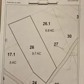
- Page: 306, 117
- Directions: From Route 142 take left onto Reeds Mills Rd to Bray Hill Rd. Lots begin at orange markers on left to last pole before the first small camp and wrap around the back side of camp. See tax map.
- Latitude: 44.883788
- Longitude: -$70.36
- Association: No
- Tax Lot: 26 & 26.1
- Tax Book Number: 3534, 4610
- Tax Map Number: 005
- Tax Year: 2025
- Tax Annual Amount: $1.00
- Parking Features: No Driveway
- Parking: No Parking
- Virtual Tour URL Unbranded: https://www.propertypanorama.com/instaview/mreis/1640616
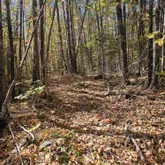
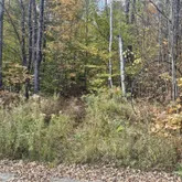
- Lot Features: Rolling/Sloping, Harvestable Crops, Wooded, Rural
- Lot Size Acres: 15.5
- Lot Size Area: 15.5
- Lot Size Source: Public Records
- Lot Size Square Feet: 675180.0
- Lot Size Units: Acres
- Roads: Dead End, Gravel, Public, Dirt
- Road Surface Type: Gravel, Dirt
- Tree Growth: false
- Site: Harvestable Crops, Rolling/Sloping, Wooded
- Development Status: Raw Land
- Property Type: Land
- Deed: All
- Deed Type Offered: Warranty
- Surveyed: No
- List Price/Acre: $9,677.42
- Electric: No Electric
- Gas: No Gas
- Utilities On: No
- Driveway: No Driveway
Property History for 5 Map Road
| Date | Event & Source | Price | Appreciation |
|---|---|---|---|
| Oct 11, 2025 | Listed (Active) Maine Listings #1640616 | $150,000 | — |
| Date | Event & Source | Price |
|---|---|---|
| 10/11/2025 | Listed (Active) Maine Listings #1640616 | $150,000 |
For completeness, we often displays two records for one sale: the MLS record and the public record.
Schools near 5 Map Road
Rating | School | Type | Grades | Distance |
|---|---|---|---|---|
| Public - | PK to 4 | |||
| Public - | 5 to 8 | |||
| Public - | 9 to 12 | |||
| Public - | PK to 8 |
Rating | School | Distance |
|---|---|---|
Phillips Elementary School PublicPK to 4 | ||
Day Mountain Regional Middle School Public5 to 8 | ||
Mt Abram Regional High School Public9 to 12 | ||
Strong Elementary School PublicPK to 8 |
School ratings and boundaries are provided by GreatSchools.org and Pitney Bowes. This information should only be used as a reference. Proximity or boundaries shown here are not a guarantee of enrollment. Please reach out to schools directly to verify all information and enrollment eligibility.
Similar Homes
Explore Nearby Homes
- East Central Franklin Homes for Sale
- Sandy River Homes for Sale
- West Central Franklin Homes for Sale
- Dallas Homes for Sale
- Carrabassett Valley Homes for Sale
- South Franklin Homes for Sale
- Coplin Homes for Sale
- North Franklin Homes for Sale
- Byron Homes for Sale
- Lakes & Mountains Homes for Sale
- Wyman Homes for Sale
- Northwest Somerset Homes for Sale
- Central Somerset Homes for Sale
- Dixfield Center Homes for Sale
- North Oxford Homes for Sale
- Phillips Homes for Sale
- Weld Homes for Sale
- Temple Homes for Sale
- Strong Homes for Sale
- Avon Homes for Sale
- Stratton Homes for Sale
- Farmington Homes for Sale
- New Vineyard Homes for Sale
- Carthage Homes for Sale
- Kingfield Homes for Sale
- Rangeley Homes for Sale
- Wilton Homes for Sale
- Madrid Township Homes for Sale
- Roxbury Homes for Sale
- New Portland Homes for Sale
- 04970 Homes for Sale
- 04984 Homes for Sale
- 04983 Homes for Sale
- 04285 Homes for Sale
- 04294 Homes for Sale
- 04982 Homes for Sale
- 04947 Homes for Sale
- 04938 Homes for Sale
- 04956 Homes for Sale
- 04224 Homes for Sale
- 04275 Homes for Sale
- 04961 Homes for Sale
- 04964 Homes for Sale
- 04955 Homes for Sale
- 04936 Homes for Sale
No guarantee, warranty or representation of any kind is made regarding the completeness or accuracy of any information, descriptions or measurements (including square footage measurements and property condition), such should be independently verified through appropriate means, including, but not limited to, in person inspection and public records, and Compass International Holdings, its subsidiaries, affiliates and independently owned and operated franchisees, and their affiliated agents and associated third parties expressly disclaim any liability in connection therewith. Photos may be virtually staged or digitally enhanced and may not reflect actual property conditions. Offers of compensation are subject to change at the seller's discretion. No financial or legal advice provided. Equal Housing Opportunity.
Listing Courtesy of Summit Real Estate
Listing data is derived in whole or in part from the Maine IDX and is for consumers' personal, noncommercial use only. Dimensions are approximate and not guaranteed. All data should be independently verified. © 2026 Maine Real Estate Information System, Inc. All Rights Reserved.
