Tbd Connors Road


Description
- Listed by BRUCE MAKI • UP NORTH REALTYP: (906)-201-1628 C: (906)-201-1628 bruce@upnorthrealty.com
Property Details for Tbd Connors Road
Property Details for Tbd Connors Road
| Status | Closed |
|---|---|
| MLS # | 10066232 |
| Days on Market | 450 |
| Taxes | - |
| HOA Fees | - |
| Condo/Co-op Fees | - |
| Property Type | Land |
| MLS Type | Land |
| Year Built | - |
| Lot Size | 40.00 AC |
| County | Iron County |
Location
Sold By UP NORTH REALTY
Building Information for Tbd Connors Road
Payment Calculator
$196 per month
30 year fixed, 6.55% Interest
$196
$0
$0
Know your buying power with a preapproval and custom rate in minutes
 1
1Property Information for Tbd Connors Road
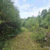
- Directions: From the US 2/Gibb City Road junction (near mile marker 81) take the Gibb City Road north for 9.0 miles. The Gibb City Road/Ponozzo Road junction meet at this point. Continue north on the Ponozzo Road for 6.0 miles to USFS Road 2130. Turn right on USFS 2130 Road and go 1.0 miles to USFS 2138 Road/Connors Road. Turn right on USFS 2138 Road/Connors Road and go 4.2 miles to fork (leaves trail 15 at this point). Turn right at the fork and go .2 miles to the access road. Turn left on access road and go .3 miles to the south property line (You will have to park app. one-quarter mile from the property line and walk in because of a beaver dam. Remove this and you will be able to drive into the property).
- MLS Area Major: Hematite Twp (36008)
- Water Body Name: Unnamed Creek
- Association: No
- Parcel Number: 003-230-002-00
- Frontage Length: 1400.0
- Frontage Type: Waterfront
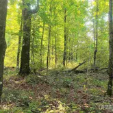
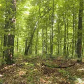
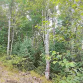
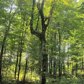
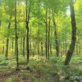
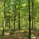
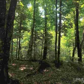
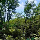
- Lot Features: Wooded, Rolling Slope
- Lot Size Acres: 40.0
- Road Surface Type: Gravel
- Property Type: Land
- Utilities: Sewer Not Available
Property History for Tbd Connors Road
| Date | Event & Source | Price | Appreciation |
|---|---|---|---|
| Jan 31, 2023 | Sold MiRealSource #10066232 | $38,500 | — |
| Nov 26, 2022 | Contract Signed MiRealSource #10066232 | — | |
| Aug 3, 2021 | Listed (Active) MiRealSource #10066232 | $41,000 | — |
| Date | Event & Source | Price |
|---|---|---|
| 01/31/2023 | Sold MiRealSource #10066232 | $38,500 |
| 11/26/2022 | Contract Signed MiRealSource #10066232 | — |
| 08/03/2021 | Listed (Active) MiRealSource #10066232 | $41,000 |
For completeness, we often displays two records for one sale: the MLS record and the public record.
Schools near Tbd Connors Road
Rating | School | Type | Grades | Distance |
|---|---|---|---|---|
| Public - | PK to 12 |
Rating | School | Distance |
|---|---|---|
Forest Park School PublicPK to 12 |
School ratings and boundaries are provided by GreatSchools.org and Pitney Bowes. This information should only be used as a reference. Proximity or boundaries shown here are not a guarantee of enrollment. Please reach out to schools directly to verify all information and enrollment eligibility.
Similar Homes
Nearby off-market homes
| Address | Sold price | Beds | Baths | Sqft | Lot AC |
|---|---|---|---|---|---|
– | – | – | – | 33.66 | |
– | – | 1 | 864 | 0.68 | |
– | – | – | – | 0.70 | |
– | – | 2 | 1,144 | 27.07 | |
– | – | – | – | 17.21 | |
– | – | – | – | 7.5 | |
$46,500 | – | – | – | 1.5 | |
– | – | – | – | 1.5 | |
– | – | 1 | 984 | 1.27 | |
– | – | – | 516 | 1.38 | |
$45,000 | – | – | – | 1.49 | |
$35,000 | – | – | – | 2.64 | |
– | – | – | 768 | 1.08 | |
– | – | – | – | 39.78 | |
$45,000 | – | – | – | 1.44 |
Explore Nearby Homes
- Alvin Homes for Sale
- Bates Township - Iron County Homes for Sale
- Crystal Falls Township - Iron County Homes for Sale
- Hematite Township - Iron County Homes for Sale
- Iron River Township - Iron County Homes for Sale
- Mastodon Township - Iron County Homes for Sale
- Stambaugh Township - Iron County Homes for Sale
- Tipler Homes for Sale
- Watersmeet Township - Gogebic County Homes for Sale
- Duncan Township - Houghton County Homes for Sale
- Covington Township - Baraga County Homes for Sale
- Interior Township - Ontonagon County Homes for Sale
- Hiles Homes for Sale
- Popple River Homes for Sale
- Haight Township - Ontonagon County Homes for Sale
- Watton Homes for Sale
- Phelps Homes for Sale
- Iron River Homes for Sale
- Gaastra Homes for Sale
- Caspian Homes for Sale
- Amasa Homes for Sale
- Florence Homes for Sale
- Sidnaw Homes for Sale
- Crystal Falls Homes for Sale
- Alpha Homes for Sale
- Conover Homes for Sale
- Long Lake Homes for Sale
- Trout Creek Homes for Sale
- Watersmeet Homes for Sale
- Land O'Lakes Homes for Sale
- 54554 Homes for Sale
- 49969 Homes for Sale
- 49970 Homes for Sale
- 54542 Homes for Sale
- 49915 Homes for Sale
- 49920 Homes for Sale
- 49927 Homes for Sale
- 49961 Homes for Sale
- 49967 Homes for Sale
- 54121 Homes for Sale
- 49903 Homes for Sale
- 49919 Homes for Sale
- 54519 Homes for Sale
- 54521 Homes for Sale
- 49902 Homes for Sale
No guarantee, warranty or representation of any kind is made regarding the completeness or accuracy of any information, descriptions or measurements (including square footage measurements and property condition), such should be independently verified through appropriate means, including, but not limited to, in person inspection and public records, and Compass International Holdings, its subsidiaries, affiliates and independently owned and operated franchisees, and their affiliated agents and associated third parties expressly disclaim any liability in connection therewith. Photos may be virtually staged or digitally enhanced and may not reflect actual property conditions. Offers of compensation are subject to change at the seller's discretion. No financial or legal advice provided. Equal Housing Opportunity. Subject to change at any time. Compass, Inc., its subsidiaries, affiliates and their agents and associated third parties make no guarantee, warranty or representation regarding the accuracy of any waterfront feature, water view or waterfront view.
Listing Courtesy of UP NORTH REALTY
Provided through IDX via MiRealSource. Courtesy of MiRealSource Shareholder. The information published and disseminated by MiRealSource is communicated verbatim, without change by MiRealSource, as filed with MiRealSource by its members. The accuracy of all information, regardless of source, is not guaranteed or warranted. All information should be independently verified. Copyright 2026 MiRealSource. All rights reserved. The information provided hereby constitutes proprietary information of MiRealSource, Inc. and its shareholders, affiliates and licensees and may not be reproduced or transmitted in any form or by any means, electronic or mechanical, including photocopy, recording, scanning or any information storage and retrieval system, without written permission from MiRealSource, Inc.
