Description
- Listed by Adolphson Real Estate, Inc
Property Details for Tbd County Rd L
Property Details for Tbd County Rd L
| Status | Active |
|---|---|
| MLS # | 6747890 |
| Days on Market | 170 |
| Taxes | $452 / year |
| HOA Fees | - |
| Condo/Co-op Fees | - |
| Compass Type | Land |
| MLS Type | Land |
| Year Built | - |
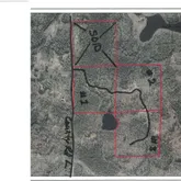
| Lot Size | 40.00 AC |
| County | Douglas County |
Location
Building Information for Tbd County Rd L
Payment Calculator
$527 per month
30 year fixed, 6.28% Interest
$489
$38
$0
Property Information for Tbd County Rd L
- City Name: Hawthorne
- County Or Parish: Douglas
- County: Douglas-WI
- Directions: Hwy 53 to County Rd L to the property
- Latitude: 46.484868415
- Longitude: -91.9688372213
- Map Coordinate: 999-A1
- Map Coordinate Source: King's Street Atlas
- City and Location: Hawthorne
- City and Location Text: Hawthorne(WI)
- Postal Code: 54874
- State Or Province: WI
- Public Survey Township: 46
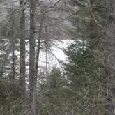
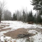
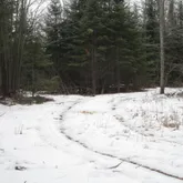
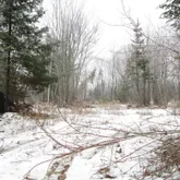
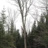
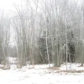
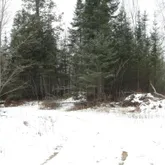
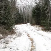
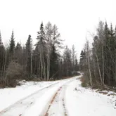
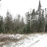
- Topography: Wooded
- Additional Parcels: No
- Association Fee: $.00
- Association: No
- Parcel Number: QA0220015000
- Tax Annual Amount: $452.00
- Tax Legal Description: SE NE 10-46-13
- Tax Other Annual Assessment Amount: $.00
- Tax Year: 2024
- Tax With Assessments: 452.0400
- High School District: 5397 - Solon Springs
- School District Number: 5397
- School District Phone: 715-378-2263
- Lot Size Area: 40.0
- Lot Size Dimensions: 1320 x 1320
- Lot Size Units: Acres
- Program Acres Total: 0.0000
- Property Type: Land
- Utilities: None Connected, None Available
Property History for Tbd County Rd L
| Date | Event & Source | Price | Appreciation |
|---|---|---|---|
| Jul 1, 2025 | Price Change NorthStar #6747890 | $99,000 | — |
| Jul 1, 2025 | Listed (Active) NorthStar #6747890 | — |
| Date | Event & Source | Price |
|---|---|---|
| 07/01/2025 | Price Change NorthStar #6747890 | $99,000 |
| 07/01/2025 | Listed (Active) NorthStar #6747890 | — |
For completeness, Compass often displays two records for one sale: the MLS record and the public record.
Schools near Tbd County Rd L
Rating | School | Type | Grades | Distance |
|---|---|---|---|---|
| Public - | PK to 5 | |||
| Public - | 6 to 8 | |||
| Public - | 9 to 12 | |||
| Public - | PK to 5 |
Rating | School | Distance |
|---|---|---|
Four Corners Elementary School PublicPK to 5 | ||
Superior Middle School Public6 to 8 | ||
Superior High School Public9 to 12 | ||
Lake Superior Elementary School PublicPK to 5 |
School ratings and boundaries are provided by GreatSchools.org and Pitney Bowes. This information should only be used as a reference. Proximity or boundaries shown here are not a guarantee of enrollment. Please reach out to schools directly to verify all information and enrollment eligibility.
Similar Homes
Similar Sold Homes
Explore Nearby Homes
- Amnicon Homes for Sale
- Bennett Homes for Sale
- Lakeside Homes for Sale
- Oakland Homes for Sale
- Parkland Homes for Sale
- Summit Homes for Sale
- Superior Town Homes for Sale
- Park Point Homes for Sale
- Allouez-Itasca Homes for Sale
- East End Superior Homes for Sale
- South Superior Homes for Sale
- Superior Village Homes for Sale
- Cloverland Homes for Sale
- Central Superior Homes for Sale
- North End Superior Homes for Sale
- Superior Homes for Sale
- Solon Springs Homes for Sale
- Hawthorne Homes for Sale
- Gordon Homes for Sale
- Poplar Homes for Sale
- Duluth Homes for Sale
- South Range Homes for Sale
- Foxboro Homes for Sale
- Maple Homes for Sale
- Lake Nebagamon Homes for Sale
- Brule Homes for Sale
- Hermantown Homes for Sale
- Proctor Homes for Sale
- Holyoke Homes for Sale
- Esko Homes for Sale
- 54880 Homes for Sale
- 54842 Homes for Sale
- 54849 Homes for Sale
- 54864 Homes for Sale
- 54873 Homes for Sale
- 55802 Homes for Sale
- 54836 Homes for Sale
- 54854 Homes for Sale
- 54838 Homes for Sale
- 54830 Homes for Sale
- 55806 Homes for Sale
- 55808 Homes for Sale
- 55807 Homes for Sale
- 55805 Homes for Sale
- 55812 Homes for Sale
No guarantee, warranty or representation of any kind is made regarding the completeness or accuracy of descriptions or measurements (including square footage measurements and property condition), such should be independently verified, and Compass, Inc., its subsidiaries, affiliates and their agents and associated third parties expressly disclaims any liability in connection therewith. Photos may be virtually staged or digitally enhanced and may not reflect actual property conditions. Offers of compensation are subject to change at the discretion of the seller. No financial or legal advice provided. Equal Housing Opportunity.
Listing Courtesy of Adolphson Real Estate, Inc
Properties displayed may be listed or sold by various participants in the MLS. Based on information submitted to the MLS GRID as of 12/18/2025 10:09 PM. All data is obtained from various sources and may not have been verified by broker orMLS GRID. Supplied Open House Information is subject to change without notice. All informationshould be independently reviewed and verified for accuracy. Properties may or may not be listed bythe office/agent presenting the information.