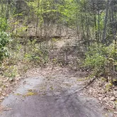
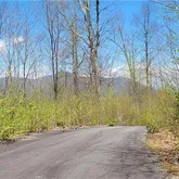
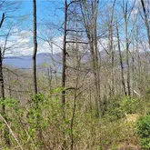
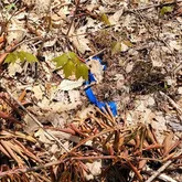
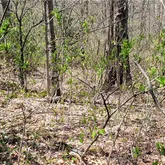
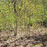
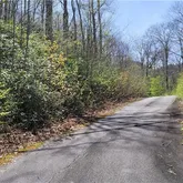
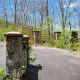
off Angel Falls Trail


Description
- Listed by Thomas Mallette • Better Homes and Gardens Real Estate Heritage
Property Details for Off Angel Falls Trail
Property Details for Off Angel Falls Trail
| Status | Closed |
|---|---|
| MLS # | 3734271 |
| Days on Market | 10 |
| Taxes | - |
| HOA Fees | - |
| Condo/Co-op Fees | - |
| Compass Type | - |
| MLS Type | - |
| Year Built | - |
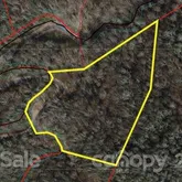
| Lot Size | 4.57 AC / 199,156 SF |
| County | Haywood County |
Location
Sold By Better Homes and Gardens Real Estate Heritage
Building Information for Off Angel Falls Trail
Payment Calculator
$232 per month
30 year fixed, 6.15% Interest
$232
$0
$0
Property Information for Off Angel Falls Trail
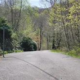
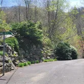
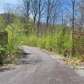
- Road Frontage Type: Paved Road, Private Road
- Longitude: -83.075661
- Geocode Source: Manual
- Latitude: 35.494448
- Directions: HWY 19 into Maggie Valley to left on Dogwood Road. Follow to left on Overlook to Left on Mountain. Follow to Summit Drive and go up Mountain to right on Angel Falls Drive. Follow through gate to the lot on the left.
- Zoning NCM: NONE
- HOA Subject To: None
- HOA Subject To Dues: No
- Tax Assessed Value: $47,100.00
- Parcel Number: 7685-79-1860
- Middle Or Junior School: Waynesville
- High School: Tuscola
- Elementary School: Jonathan Valley
- Elevation: 4000
- Structure Type: Lot
- Sq Ft Building Minimum: 0
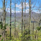
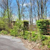
- Lot Features: Adjoins Forest, Mountain View, Year Round View
- Lot Size Dimensions: irregular
- Possible Use: Private Estate, Recreational/2nd House, Residential
- Property Type: Land
- Photos Count: 15
- Road Responsibility: Private Maintained Road
- Permit Syndication: Yes
- Plat Book Slide: CABC/3913
- Restrictions: No Representation, Other - See Media/Remarks
- Sewer: Septic Needed
- Water Source: Other
- Out Buildings: No
- Road Surface Type: Paved
- Habitable Residence YN: No
- Bedrooms Septic: 3
- Unit Count: 0
Property History for Off Angel Falls Trail
| Date | Event & Source | Price | Appreciation |
|---|---|---|---|
| May 28, 2021 | Closed CANOPY #3734271 | $47,500 | — |
| May 10, 2021 | Under Contract-No Show CANOPY #3734271 | — | |
| May 10, 2021 | Under Contract-Show CANOPY #3734271 | — | |
| Apr 28, 2021 | Listed (Active) CANOPY #3734271 | $50,000 | — |
| Date | Event & Source | Price |
|---|---|---|
| 05/28/2021 | Closed CANOPY #3734271 | $47,500 |
| 05/10/2021 | Under Contract-No Show CANOPY #3734271 | — |
| 05/10/2021 | Under Contract-Show CANOPY #3734271 | — |
| 04/28/2021 | Listed (Active) CANOPY #3734271 | $50,000 |
For completeness, Compass often displays two records for one sale: the MLS record and the public record.
Schools near Off Angel Falls Trail
Rating | School | Type | Grades | Distance |
|---|---|---|---|---|
| Public - | PK to 5 | |||
| Public - | 6 to 8 | |||
| Public - | 9 to 12 | |||
| Public - | 9 to 13 |
Rating | School | Distance |
|---|---|---|
Jonathan Valley Elementary PublicPK to 5 | ||
Waynesville Middle Public6 to 8 | ||
Tuscola High Public9 to 12 | ||
Haywood Early Colleg Public9 to 13 |
School ratings and boundaries are provided by GreatSchools.org and Pitney Bowes. This information should only be used as a reference. Proximity or boundaries shown here are not a guarantee of enrollment. Please reach out to schools directly to verify all information and enrollment eligibility.
Similar Homes
Similar Sold Homes
Explore Nearby Homes
- Barkers Creek Township - Jackson County Homes for Sale
- Cataloochee Township - Haywood County Homes for Sale
- Charleston Township - Swain County Homes for Sale
- Ivy Hill Township - Haywood County Homes for Sale
- Jonathan Creek Township - Haywood County Homes for Sale
- Maggie Valley Country Club Estates Homes for Sale
- Qualla Township - Jackson County Homes for Sale
- Scott Creek Township - Jackson County Homes for Sale
- Sylva Township - Jackson County Homes for Sale
- Waynesville Township - Haywood County Homes for Sale
- Villages of Plott Creek Homes for Sale
- Dillsboro Township - Jackson County Homes for Sale
- Iron Duff Township - Haywood County Homes for Sale
- Clyde Township - Haywood County Homes for Sale
- Dillsboro Homes for Sale
- Waynesville Homes for Sale
- Maggie Valley Homes for Sale
- Lake Junaluska Homes for Sale
- Cherokee Homes for Sale
- Sylva Homes for Sale
- Balsam Homes for Sale
- Clyde Homes for Sale
- Whittier Homes for Sale
- Cullowhee Homes for Sale
- Leicester Homes for Sale
- Canton Homes for Sale
- Bryson City Homes for Sale
- Hartford Homes for Sale
- Del Rio Homes for Sale
- Candler Homes for Sale
- 28789 Homes for Sale
- 28719 Homes for Sale
- 28779 Homes for Sale
- 28785 Homes for Sale
- 28786 Homes for Sale
- 28745 Homes for Sale
- 28707 Homes for Sale
- 28721 Homes for Sale
- 28716 Homes for Sale
- 28723 Homes for Sale
- 28713 Homes for Sale
- 37738 Homes for Sale
- 28734 Homes for Sale
- 37722 Homes for Sale
- 28783 Homes for Sale
No guarantee, warranty or representation of any kind is made regarding the completeness or accuracy of descriptions or measurements (including square footage measurements and property condition), such should be independently verified, and Compass, Inc., its subsidiaries, affiliates and their agents and associated third parties expressly disclaims any liability in connection therewith. Photos may be virtually staged or digitally enhanced and may not reflect actual property conditions. Offers of compensation are subject to change at the discretion of the seller. No financial or legal advice provided. Equal Housing Opportunity.
Listing Courtesy of Better Homes and Gardens Real Estate Heritage
Based on information submitted to the MLS GRID as of 05/29/2021 12:00 PM. All data is obtained from various sources and may not have been verified by broker or MLS GRID. Supplied Open House Information is subject to change without notice. All information should be independently reviewed and verified for accuracy. Properties may or may not be listed by the office/agent presenting the information. Properties displayed may be listed or sold by various participants in the MLS. IDX information is provided exclusively for consumers’ personal, non-commercial use and may not be used for any purpose other than to identify prospective properties consumers may be interested in purchasing. The data is deemed reliable but is not guaranteed by MLS GRID. Use of the MLS GRID data may be subject to an end user license agreement prescribed by the applicable MLS of the Member Participant, if any, and as amended from time to time.