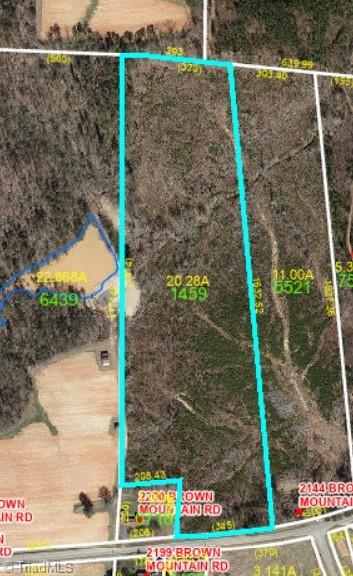
0 Brown Mountain Road
0 Brown Mountain Road
Closed 4/21/22
Closed 4/21/22

Description
- Listed by Joe Hooker • Carolina Farms & Homes - King
Property Details for 0 Brown Mountain Road
Location
Sold By Reel Realty
Property Details for 0 Brown Mountain Road
| Status | Closed |
|---|---|
| MLS # | 1048577 |
| Days on Market | 105 |
| Taxes | $608 / year |
| HOA Fees | - |
| Condo/Co-op Fees | - |
| Compass Type | Land |
| MLS Type | Land / Single Family Residence |
| Year Built | - |
| Lot Size | 16.37 AC |
| County | Stokes County |
Location
Sold By Reel Realty
Building Information for 0 Brown Mountain Road
Payment Calculator
$569 per month
30 year fixed, 7.25% Interest
$518
$51
$0
Property Information for 0 Brown Mountain Road
- County Or Parish: Stokes
- City: Pilot Mountain
- Directions: From King take HWY 52 to Pinnacle exit, right on Perch, left on Old 52, right on Hwy 268, left Osborne Joyce, Left Brown Mtn Rd.
- Latitude: 36.44283
- Longitude: -80.403765
- Postal Code: 27041
- City Limits: No
- List AOR: Winston-Salem
- Tax Rate: .74%
- Tax Annual Amount: $607.54
- Tax Assessed Value: $82,100.00
- Tax Year: 2021
- Parcel Number: 5988731459
- Association: No
- High School: North Stokes
- Elementary School: Nancy Reynolds
- Lot Features: Wooded
- Lot Size Acres: 16.37
- Road Frontage Type: 2-Lane
- Cleared Acres: 15.0
- Frontage Length: Total Road Frontage: 345
- Total Heated Finished SqFt Range: 0 - 0
- Possible Use: Hunting, Manufactured, Modular, Recreational, Single Res
- Documents Available: Aerial
- Photos Count: 1
- Property Type: Land
- Deed Book: 660
- Deed Page: 1382
- Listing Agreement: Exclusive Right To Sell
Property History for 0 Brown Mountain Road
| Date | Event & Source | Price | Appreciation |
|---|
| Date | Event & Source | Price |
|---|
For completeness, Compass often displays two records for one sale: the MLS record and the public record.
Schools near 0 Brown Mountain Road
Rating | School | Type | Grades | Distance |
|---|---|---|---|---|
| Public - | PK to 5 | |||
| Public - | 6 to 8 | |||
| Public - | 9 to 12 | |||
| Public - | 9 to 12 |
Rating | School | Distance |
|---|---|---|
Westfield Elementary School PublicPK to 5 | ||
Pilot Mountain Middle School Public6 to 8 | ||
East Surry High School Public9 to 12 | ||
Surry Early College Public9 to 12 |
School ratings and boundaries are provided by GreatSchools.org and Pitney Bowes. This information should only be used as a reference. Proximity or boundaries shown here are not a guarantee of enrollment. Please reach out to schools directly to verify all information and enrollment eligibility.
Similar Homes
Similar Sold Homes
Homes for Sale near Quaker Gap Township - Stokes County
Neighborhoods
- Big Creek Township - Stokes County
- Eldora Township - Surry County
- Long Hill Township - Surry County
- Mount Airy Township - Surry County
- Pilot Township - Surry County
- Quaker Gap Township - Stokes County
- Shoals Township - Surry County
- South Westfield Township - Surry County
- Yadkin Township - Stokes County
- Rockford Township - Surry County
- White Plains
- Flat Rock
- Dobson Township - Surry County
- North Fall Creek Township - Yadkin County
- Danbury Township - Stokes County
- Virginia
- Peters Creek Township - Stokes County
- Toast
- East Bend Township - Yadkin County
- Old Richmond Township - Forsyth County
Cities
No guarantee, warranty or representation of any kind is made regarding the completeness or accuracy of descriptions or measurements (including square footage measurements and property condition), such should be independently verified, and Compass expressly disclaims any liability in connection therewith. Photos may be virtually staged or digitally enhanced and may not reflect actual property conditions. No financial or legal advice provided. Equal Housing Opportunity.
Listing Courtesy of Carolina Farms & Homes - King
The data relating to real estate for sale on this web site comes in part from the Internet Data Exchange (IDX) Program of the Triad MLS, Inc. of High Point, NC. Real estate listings held by brokerage firms other than Compass are marked with the Internet Data Exchange logo or the Internet Data Exchange (IDX) thumbnail logo (the TRIAD MLS logo) and detailed information about them includes the name of the listing brokers. Information Deemed Reliable But Not Guaranteed. The broker providing this data believes it to be correct, but advises interested parties to confirm the data before relying on it in a purchase decision. The information being provided is for consumers’ personal, non-commercial use and may not be used for any purpose other than to identify perspective properties consumers may be interested in purchasing. Any use of search facilities of data on the site, other than by potential buyers and sellers is prohibited. Copyright© 2024 Triad MLS, Inc. of High Point, NC. All Rights Reserved. Data cannot be redistributed and cannot be used for any reason other than provided in the contract.

