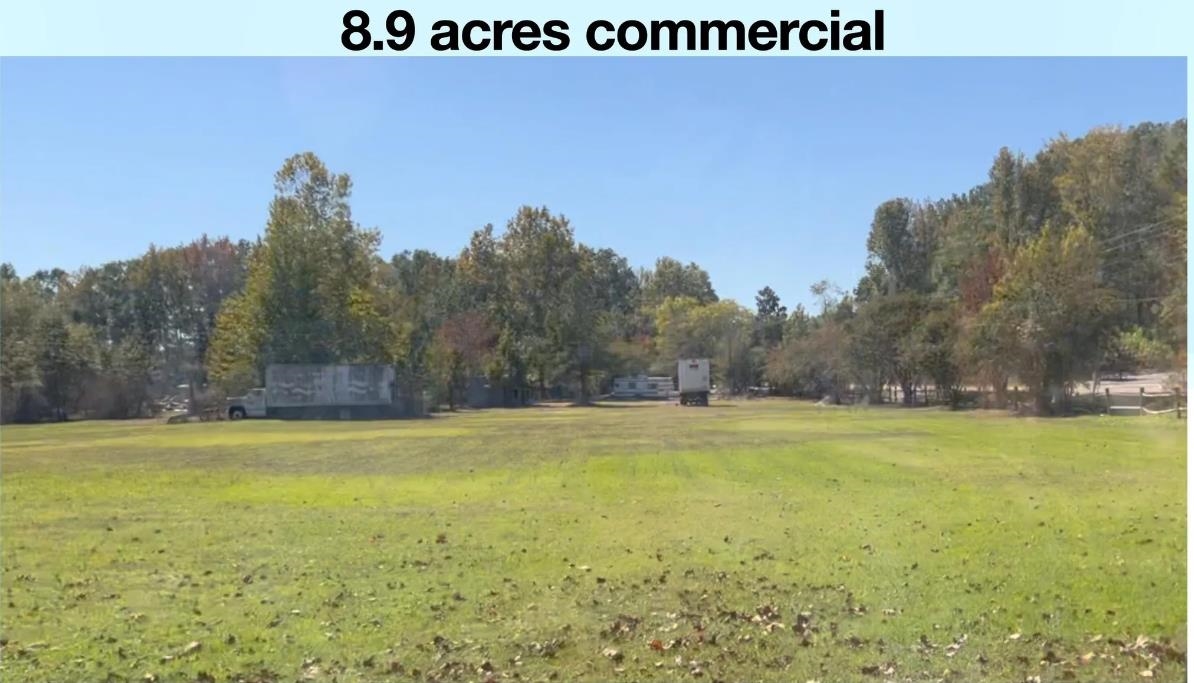
15085 Hwy 70 Highway
15085 Hwy 70 Highway
Gallaway, TN 38002
$989,900
Price
387,684 / 8.9
Lot Size / Acres
Contingent
Contingent


Description
Gallaway, TN- THE NEXT BIG EXPANSION! 8.9 Acres commercial land- flat, cleared and ready for development. Adjacent parcels sold and listed for$135K an acre. Property has sewer and water; 5 sewer taps already in place. Perfect for commercial strip center- Storage units or other commercial use.15 min from Ford Blue Opal, minutes from Helen of Troy. ALSO AVAILABLE: Adjoining 25.43 acres for residential development.Gallaway, TN- THE NEXT BIG EXPANSION! 8.9 Acres commercial land- flat, cleared and ready for development. Adjacent parcels sold and listed for$135K an acre. Property has sewer and water; 5 sewer taps already in place. Perfect for commercial strip center- Storage units or other commercial use.15 min from Ford Blue Opal, minutes from Helen of Troy. ALSO AVAILABLE: Adjoining 25.43 acres for residential development.
- Listed by Brett Bernard • The Stamps Real Estate Company
Property Details for 15085 Hwy 70 Highway
Area
651A
MAAR Subdivision NameNone
Legal Subdivision NameNone
LocationOther (See REMARKS)
Location
Listing Courtesy of The Stamps Real Estate Company
LISTING UPDATED: 04/16/2024 01:22 PM
Property Details for 15085 Hwy 70 Highway
| Status | Contingent |
|---|---|
| MLS # | 10167864 |
| Days on Market | 34 |
| Taxes | $442 / year |
| HOA Fees | - |
| Condo/Co-op Fees | - |
| Compass Type | Land |
| MLS Type | Land / Land |
| Year Built | - |
| Lot Size | 8.90 AC |
| County | Fayette County |
Location
Listing Courtesy of The Stamps Real Estate Company
Building Information for 15085 Hwy 70 Highway
Lot Size8.90 AC
Payment Calculator
$5,439 per month
30 year fixed, 7.25% Interest
Principal and Interest
$5,402
Property Taxes
$37
HOA Dues
$0
The Payment Calculator is for illustrative purposes only.
Property Information for 15085 Hwy 70 Highway
Summary
Location and General Information
- Address: 15085 HWY 70 HWY
- Address Search Number: 15085
- Directions: I 40 East to Hwy 196- Gallaway, TN. Head north to hwy 70 and turn right. Property is 1.3 miles on the right next to Sling Shot Charlies.
- Map Coordinate: A
- MLS Map Num: Fayette/Braden
- Uses Of Adjacent Area: Retail, Food Service, Commercial
Taxes and HOA Information
- LVT Date: 03-14-2024
Property
Lot Information
- Lot Size: 8.9
- Acreage: 8.90
- Improvements: Improved Drainage
- Parcel ID: 038 038 00500
- Present Structure: Mobile Home
- Present Usage: None/Vacant
- Road Frontage: Paved
- Shape: Pie Shaped
- Topographic Feature: Level
- Zoning: Com
- Zoning Of Adjacent Area: Commercial
Property and Assessments
- Legal: No Known Subdivision
- Service Type: Full Service Listing
Utilities
- Utilities: Public Water, Electricity, Public Sewer
Property History for 15085 Hwy 70 Highway
| Date | Event & Source | Price | Appreciation |
|---|
| Date | Event & Source | Price |
|---|
For completeness, Compass often displays two records for one sale: the MLS record and the public record.
Similar Homes
Sorry, we can't find any similar homes at this time. Please check back later.
Similar Sold Homes
Sorry, we can't find any similar sold homes at this time. Please check back later.
Homes for Sale near Gallaway
Neighborhoods
Cities
No guarantee, warranty or representation of any kind is made regarding the completeness or accuracy of descriptions or measurements (including square footage measurements and property condition), such should be independently verified, and Compass expressly disclaims any liability in connection therewith. Photos may be virtually staged or digitally enhanced and may not reflect actual property conditions. No financial or legal advice provided. Equal Housing Opportunity.
Listing Courtesy of The Stamps Real Estate Company


