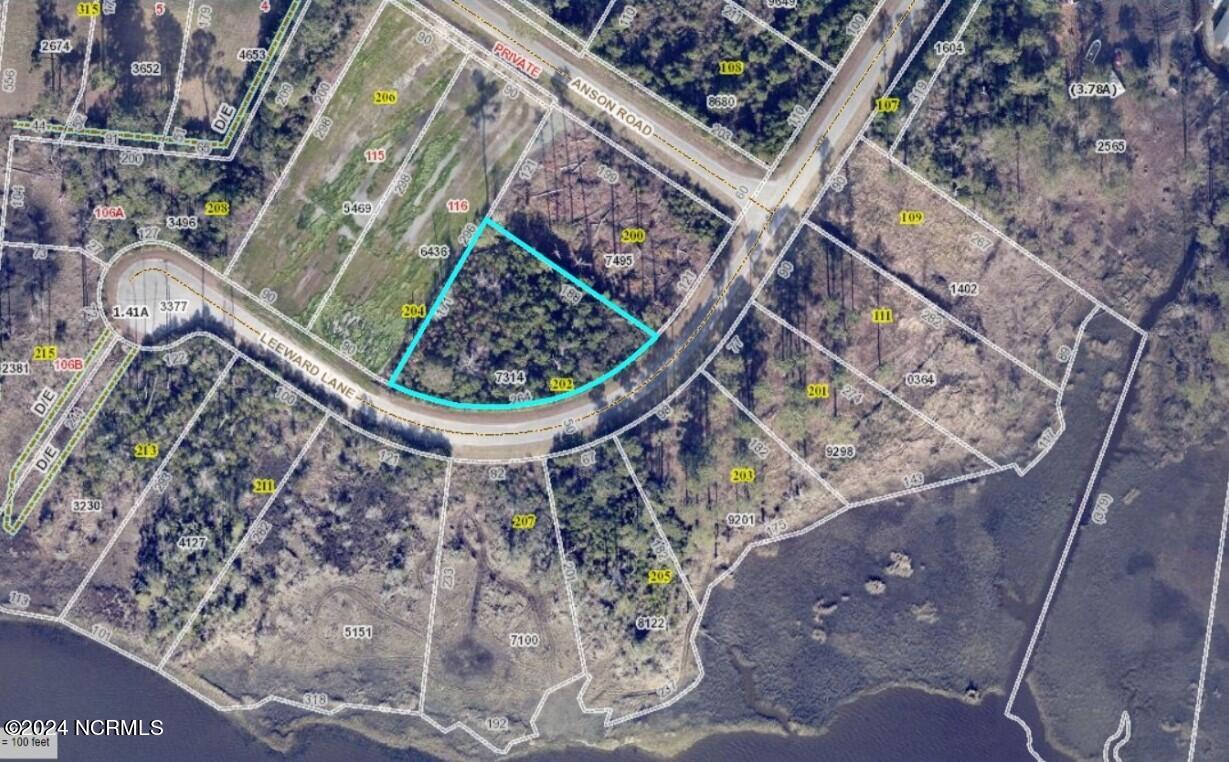
202 Leeward Lane
202 Leeward Lane

Description
- Listed by Joshua Lee Forsberg • RE/MAX Ocean Properties
Property Details for 202 Leeward Lane
Location
Property Details for 202 Leeward Lane
| Status | Active |
|---|---|
| MLS # | 100443503 |
| Days on Market | 24 |
| Taxes | - |
| HOA Fees | $500 / year |
| Condo/Co-op Fees | - |
| Compass Type | Land |
| MLS Type | Land |
| Year Built | - |
| Lot Size | 0.54 AC |
| County | Carteret County |
Location
Building Information for 202 Leeward Lane
Payment Calculator
$528 per month
30 year fixed, 7.25% Interest
$464
$22
$42
Property Information for 202 Leeward Lane
- City: Beaufort
- State Or Province: NC
- Postal Code: 28516
- County Or Parish: Carteret
- Directions: Take 70 E to Otway Turn right onto Gillikin Rd go straight until the stop sign and turn right onto Channel Rock Rd you will see the sign for Channel Rock Landing and turn left onto Leeward Lane.
- Latitude: 34.77
- Longitude: -76.57
- City Limits: No
- Secondary Subdivision: N/A
- Location Type: Mainland
- Legal and Taxes: Zoning Details: Residential
- Association Name: Channel Rock POA Inc.
- Association Phone: 252-422-2205
- Tax Other Assessment Amount Frequency: None Known
- Association Fee: $500.00
- Tax Legal Description: LOT 105 CHANNEL ROCK LANDING PH. 1
- Tax Book Number: 31
- Tax Map Number: 733701097314000
- Tax Year: 2023
- Tax Assessed Value: $55,552.00
- Parcel Number: 733701097314000
- Tax Block: 137
- Association: Yes
- Legal and Taxes: HOA: Yes
- Legal and Taxes: Cobra Zone: No
- Legal and Taxes: Deed Book: 1490
- Legal and Taxes: Deed Page: 111.0
- Legal and Taxes: Legal: LOT 105 CHANNEL ROCK LANDING PH. 1
- Legal and Taxes: PID: 733701097314000
- Legal and Taxes: Plat Book: 31
- Legal and Taxes: Plat Page: 137
- Legal and Taxes: Tax Assessed Value: $55,552.00
- Legal and Taxes: Tax Year: 2023
- Middle Or Junior School: Down East
- High School: East Carteret
- Elementary School: Harkers Island
- Legal and Taxes: Elementary School: Harkers Island
- Legal and Taxes: Middle School: Down East
- Legal and Taxes: High School: East Carteret
- Lot Features: Subdivision
- Lot Size Units: Acres
- Lot Size Acres: 0.54
- Lot Size Area: 0.54
- Lot Size Square Feet: 23348.0
- Acres - Total: 0.54
- Lot Sq Ft: 23348.0
- Total Road Frontage: 264.00
- Bldgs on Property: None: Yes
- Soil Evaluation : Soil Evaluation - No: Yes
- Lot Water Features: Water View: Yes
- Current Use: Vacant, Single Family, Residential
- Legal and Taxes: Federal Flood Insurance Available: Yes
- Legal and Taxes: Special Assessments: None Known
- Current Use: Residential: Yes
- Utilities: Electricity Available
- Association Amenities: Gated, Maint - Comm Areas, Maint - Roads
- Fencing: None
- Other Structures: None
- Fencing: None: Yes
- Fuel Tank: None: Yes
- Bathrooms Total Integer: 0
- Bathrooms Total Decimal: .00
- Bathrooms Total Notational: .00
Property History for 202 Leeward Lane
| Date | Event & Source | Price | Appreciation |
|---|
| Date | Event & Source | Price |
|---|
For completeness, Compass often displays two records for one sale: the MLS record and the public record.
Public Records for 202 Leeward Lane
Schools near 202 Leeward Lane
Rating | School | Type | Grades | Distance |
|---|---|---|---|---|
| Public - | PK to 8 | |||
| Public - | 9 to 12 | |||
| Public - | 9 to 10 | |||
| Public - | K to 12 |
Rating | School | Distance |
|---|---|---|
Smyrna Elementary School PublicPK to 8 | ||
East Carteret High School Public9 to 12 | ||
Marine Sci. & Tech. Early College HS Public9 to 10 | ||
Bridges School PublicK to 12 |
School ratings and boundaries are provided by GreatSchools.org and Pitney Bowes. This information should only be used as a reference. Proximity or boundaries shown here are not a guarantee of enrollment. Please reach out to schools directly to verify all information and enrollment eligibility.
Similar Homes
Similar Sold Homes
Homes for Sale near Straits Township - Carteret County
Neighborhoods
- Beaufort Township - Carteret County
- Davis Township - Carteret County
- Eastman Creek Landing
- Harkers Island Township - Carteret County
- Harlowe Township - Carteret County
- Merrimon Bay
- Merrimon Township - Carteret County
- Morehead Township - Carteret County
- Olde Beaufort Village
- Smyrna Township - Carteret County
- Straits Township - Carteret County
- Buccaneer Bay
- Spinnaker Point
- Oriental Plantation
- Sail Haven
- Marshallberg Township - Carteret County
- Sea Spray Condominiums
Cities
No guarantee, warranty or representation of any kind is made regarding the completeness or accuracy of descriptions or measurements (including square footage measurements and property condition), such should be independently verified, and Compass expressly disclaims any liability in connection therewith. Photos may be virtually staged or digitally enhanced and may not reflect actual property conditions. No financial or legal advice provided. Equal Housing Opportunity. Subject to change at any time. Compass makes no guarantee, warranty or representation regarding the accuracy of any waterfront feature, water view or waterfront view.
Listing Courtesy of RE/MAX Ocean Properties
The data relating to real estate on this website comes in part from the Internet Data Exchange program of North Carolina Regional MLS LLC. All information is deemed reliable but not guaranteed and should be independently verified. All properties are subject to prior sale, change, or withdrawal. Neither listing broker(s) nor Compass shall be responsible for any typographical errors, misinformation, or misprints, and shall be held totally harmless from any damages arising from reliance upon these data. Copyright© 2024 North Carolina Regional MLS LLC. All Rights Reserved.
