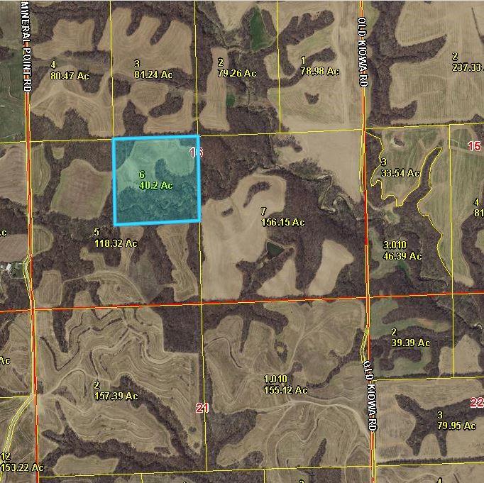
40.2-ac Mineral Point Road
40.2-ac Mineral Point Road


Description
- Listed by Denita Hansen • Colonial Realty Inc • 913-426-8751
Property Details for 40.2-ac Mineral Point Road
Location
Property Details for 40.2-ac Mineral Point Road
| Status | Active |
|---|---|
| MLS # | 2475436 |
| Days on Market | 53 |
| Taxes | $562 / year |
| HOA Fees | - |
| Condo/Co-op Fees | - |
| Compass Type | Land |
| MLS Type | Land / Farm |
| Year Built | - |
| Lot Size | 40.20 AC |
| County | Doniphan County |
Location
Building Information for 40.2-ac Mineral Point Road
Payment Calculator
$2,694 per month
30 year fixed, 7.25% Interest
$2,647
$47
$0
Property Information for 40.2-ac Mineral Point Road
- City: Troy
- County Or Parish: Doniphan
- Directions: From Exit 136 on US 36 at Troy, Kansas turn left onto KS-136 South/Last Chance Road go 4.9 miles . Turn left onto 150th Road 1 mile. Turn right onto Mineral Point road. After about `.5 miles, look for the sign on your left. That old county road will lead back to the 40 acres. From Atchison. From the corner of S 2nd and Atchison Street, turn right onto Atchison Street (.1 mile).Turn left on River Road and go 2.2 miles. Turn right to stay on River Road .6 miles. Turn left to stay on River road 1.8 miles. continue straight onto Mineral Point Road 5.7 miles. See the sign.Turn right into the old county road. You will reach the land in about 1/4 mile. Park at the top of the hill, walk down to the field.
- Inside City Limits: No
- Latitude: 39.7026433
- Longitude: -95.07056617
- MLS Area Major: 145 - Doniphan Co Ks
- Postal Code: 66087
- State Or Province: KS
- Subdivision Name: None
- Topography: Level,Rolling,Terraced
- Association: No
- Tax Special Amount: 0
- Tax Annual Amount: $562.00
- Parcel Number: 999999
- Tax Annual Amount: $562.40
- Township: 04
- High School: Troy
- High School District: USD 429
- Elementary School: Troy
- Middle School: Troy
- Virtual Tour URL Branded: https://www.coloniallistings.com/property-videos
- Cultivated Area: 16.19
- Agriculture Type: Grain/Crops
- Crops: Tenant Owned
- Mineral Description: All Rights Included
- RANGE: 21E
- Soil Type: Loamy,Other
- Lot Description: Acreage, Stream(s), Treed
- Lot Size Area: 40.20
- Lot Size Source: Public Records
- Lot Size Square Feet: 1,751,112.00
- Lot Size Units: Acres
- Vegetation: Crop(s), Partially Wooded
- Current Use: Agriculture
- Development Status: Raw Land
- Documents Available: Aerial Photos
- Documents Count: 3
- FEMA 100 Yr Flood Plain: No
- Section: 16
- Listing Agreement: Exclusive Right To Sell
- Photos Count: 9
- Possible Use: Agricultural
- Utilities: None
- Water Source: No Water
- Possession: Funding
- Road Frontage Type: County Road, Unpaved Streets
- Road Responsibility: Private Maintenance
- Bathrooms Total Integer: 0
- Maintenance Provided YN: 0
- Deposit: Colonial Realty Trust
Property History for 40.2-ac Mineral Point Road
| Date | Event & Source | Price | Appreciation |
|---|
| Date | Event & Source | Price |
|---|
For completeness, Compass often displays two records for one sale: the MLS record and the public record.
Schools near 40.2-ac Mineral Point Road
Rating | School | Type | Grades | Distance |
|---|---|---|---|---|
| Public - | PK to 6 | |||
| Public - | 7 to 12 |
Rating | School | Distance |
|---|---|---|
Troy Elementary School PublicPK to 6 | ||
Troy High And Middle School Public7 to 12 |
School ratings and boundaries are provided by GreatSchools.org and Pitney Bowes. This information should only be used as a reference. Proximity or boundaries shown here are not a guarantee of enrollment. Please reach out to schools directly to verify all information and enrollment eligibility.
Similar Homes
Similar Sold Homes
Homes for Sale near Wayne Township - Doniphan County
Neighborhoods
- Center Township - Atchison County
- Weston Township - Platte County
- Wayne Township - Doniphan County
- Walnut Township - Atchison County
- Union Township - Doniphan County
- Shannon Township - Atchison County
- Rush Township - Buchanan County
- Norton Township - Jefferson County
- Mount Pleasant Township - Atchison County
- Marshall Township - Platte County
- Marion Township - Doniphan County
- Lancaster Township - Atchison County
- Lake Township - Buchanan County
- Kickapoo Township - Leavenworth County
- Jefferson Township - Jefferson County
- Independence Township - Doniphan County
- Easton Township - Leavenworth County
- Center Township - Doniphan County
- Lewis and Clark Village
- Iatan
Cities
No guarantee, warranty or representation of any kind is made regarding the completeness or accuracy of descriptions or measurements (including square footage measurements and property condition), such should be independently verified, and Compass expressly disclaims any liability in connection therewith. Photos may be virtually staged or digitally enhanced and may not reflect actual property conditions. No financial or legal advice provided. Equal Housing Opportunity. Subject to change at any time. Compass makes no guarantee, warranty or representation regarding the accuracy of any waterfront feature, water view or waterfront view.
Listing Courtesy of Colonial Realty Inc
Based on information from one of the following Multiple Listing Services: Heartland MLS, South Central Kansas MLS, Sunflower Association of REALTORS, Lawrence Board of REALTORS. Information being provided is for the visitor’s personal, noncommercial use and may not be used for any purpose other than to identify prospective properties visitor may be interested in purchasing. The data contained herein is copyrighted by Heartland MLS, South Central Kansas MLS, Sunflower Association of REALTORS , Lawrence Board of REALTORS is protected by all applicable copyright laws. Any dissemination of this information is in violation of copyright laws and is strictly prohibited. Property information referenced on this web site comes from the Internet Data Exchange (IDX) program of the MLS. This web site may reference real estate listing(s) held by a brokerage firm other than the broker and/or agent who owns this web site. For the avoidance of doubt, the accuracy of all information, regardless of source, is deemed reliable but not guaranteed and should be personally verified through personal inspection by and/or with the appropriate professionals.


