


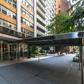


BuildingMayfair Towers
- 493 Units, 36 Stories
- Built in 1964, Post-war
- Elevators [6]
- Full-Service Building
- Pets Allowed
- Rentals Allowed
Units
Unit | Status | Price $2,065,000 Avg. | Price/Sq. Ft. $1,889/sf Avg. | Bd | Ba | Sq. Ft. | Floor Plan |
|---|---|---|---|---|---|---|---|
| 15 W 72nd St - #29C | Active | $3,600,000 | - | 2 | 2 | - | View |
| 15 W 72nd St - #36B | Active | $2,750,000 | $2,115/sf | 2 | 2 | 1,300 | View |
| 15 W 72nd St - #8TUOpen House: May 12, 10:30AM - 11:30AMVirtual Tour | Active | $1,995,000 | $1,663/sf | 2 | 2 | 1,200 | View |
| 15 W 72nd St - #8AOpen House: May 12, 12:00PM - 1:30PM | Active | $995,000 | - | 1 | 1 | - | View |
| W 72nd St | Contract Signed | $985,000 | - | 1 | 1 | - |
BuildingMayfair Towers
- 493 Units, 36 Stories
- Built in 1964, Post-war
- Elevators [6]
- Full-Service Building
- Pets Allowed
- Rentals Allowed
Building Amenities
Building PoliciesUPDATED 11/20/2023
Building Facts
Neighborhood Map and Transit
Schools
| School | Type | Grades | Distance | Rating |
|---|---|---|---|---|
| Robert Louis Stevenson School | Private | 7-12 | 0.1 mi | NR |
| The Ideal School of Manhattan | Private | K-12 | 0.2 mi | NR |
| Beit Rabban | Private | PK-5 | 0.2 mi | NR |
| School Of The Blessed Sacrament School | Private | PK-8 | 0.2 mi | NR |
Robert Louis Stevenson School 7-12, 0.1 mi, Private | NR |
The Ideal School of Manhattan K-12, 0.2 mi, Private | NR |
Beit Rabban PK-5, 0.2 mi, Private | NR |
School Of The Blessed Sacrament School PK-8, 0.2 mi, Private | NR |
School ratings and boundaries are provided by GreatSchools.org and Pitney Bowes. This information should only be used as a reference. Proximity or boundaries shown here are not a guarantee of enrollment. Please reach out to schools directly to verify all information and enrollment eligibility.

Compass is a licensed real estate broker. Information is compiled from sources deemed reliable but is subject to errors and omissions. No guarantee, warranty or representation of any kind is made regarding the completeness or accuracy of facts, descriptions or measurements (including square footage measurements and property condition), such should be independently verified, and Compass expressly disclaims any liability in connection therewith. No financial, legal or other professional advice provided. See Terms of Service for additional restrictions. Equal Housing Opportunity.
Updated as of Nov 20, 2023.