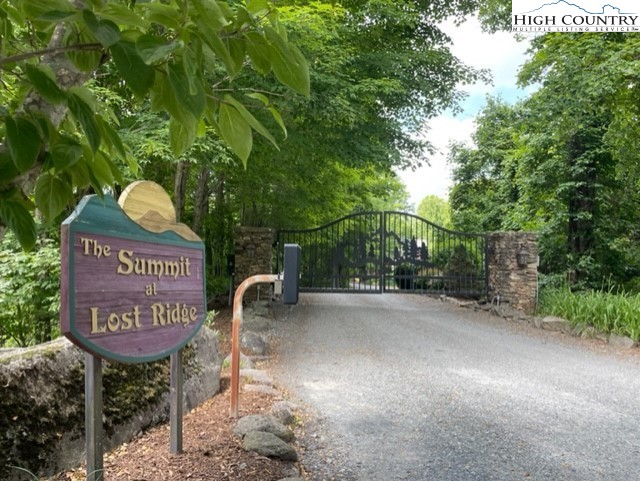
Lot #41 Lost Ridge Trail
Lot #41 Lost Ridge Trail


Description
- Listed by Jonathan Bradley • Allen Tate Ashe High Country Realty • (336) 246-6348
Property Details for Lot #41 Lost Ridge Trail
Location
Property Details for Lot #41 Lost Ridge Trail
| Status | Active |
|---|---|
| MLS # | 238478 |
| Days on Market | 547 |
| Taxes | $183 / year |
| HOA Fees | $578 / year |
| Condo/Co-op Fees | - |
| Compass Type | Land |
| MLS Type | Land / Residential |
| Year Built | - |
| Lot Size | 0.70 AC |
| County | Watauga County |
Location
Building Information for Lot #41 Lost Ridge Trail
Payment Calculator
$254 per month
30 year fixed, 7.25% Interest
$190
$15
$48
Property Information for Lot #41 Lost Ridge Trail
- Directions: Starting in downtown Boone, head West on HWY 421 for 7.8 miles, after passing Skateworld turn left onto Walls Rd, travel .3 miles then turn right onto Joe Shoemaker Rd, continue for 1 mile and turn left onto Silverstone Rd, continue .5 miles and turn left onto Old US HWY 421, continue for .2 miles and turn right at Laurel Branch Rd and drive until you see the gate on the right, approximately 1.9 miles. Laurel Branch will turn into a gravel road before you reach the development. Once through the gate, the lot is a very short drive and on your left with the Ashe High Country sign in front.
- Road Surface Type: Gravel
- Postal Code: 28692
- Road Frontage Type: PrivateRoad
- MLS Area Major: 7-Cove Creek
- Topography: Sloping
- Parcel Number: 1974601408000
- Association Fee: $577.50
- Association Fee Frequency: Annually
- Association Name: Summit at Lost Ridge Owners' Association
- Association: Yes
- Tax Annual Amount: $183
- Tax Book Number: 535/145
- Tax Lot: 41
- Elementary School: Cove Creek
- High School: Watauga
- Lot Features: Wooded
- Lot Size Acres: 0.7
- Lot Size Area: 0.7
- Lot Size Units: Acres
- Documents Available: Plat, RestrictiveCovenants, Survey
- Human Modified: Yes
- Sewer: NotConnected
- Utilities: ElectricityAvailable, HighSpeedInternetAvailable
- Water Source: NotConnected
- Community Features: Gated, LongTermRentalAllowed, ShortTermRentalAllowed
- Vegetation: Wooded
Property History for Lot #41 Lost Ridge Trail
| Date | Event & Source | Price | Appreciation |
|---|
| Date | Event & Source | Price |
|---|
For completeness, Compass often displays two records for one sale: the MLS record and the public record.
Schools near Lot #41 Lost Ridge Trail
Rating | School | Type | Grades | Distance |
|---|---|---|---|---|
| Public - | PK to 8 | |||
| Public - | 9 to 12 | |||
| Public - | 9 to 12 |
Rating | School | Distance |
|---|---|---|
Cove Creek Elementary PublicPK to 8 | ||
Watauga High Public9 to 12 | ||
Watauga Innovation Academy Public9 to 12 |
School ratings and boundaries are provided by GreatSchools.org and Pitney Bowes. This information should only be used as a reference. Proximity or boundaries shown here are not a guarantee of enrollment. Please reach out to schools directly to verify all information and enrollment eligibility.
Similar Homes
Similar Sold Homes
Homes for Sale near Cove Creek Township - Watauga County
Neighborhoods
- Laurel Creek Township - Watauga County
- New River Township - Watauga County
- Beaverdam Township - Watauga County
- Watauga Township - Watauga County
- Cove Creek Township - Watauga County
- Cove Creek
- Valle Crucis
- Meat Camp Township - Watauga County
- Brushy Fork Township - Watauga County
- Foscoe
- Shawneehaw Township - Watauga County
- Beech Mountain Township - Avery County
- Echota
- Boone Township - Watauga County
- Downtown Boone
- Blowing Rock Township - Watauga County
- Mill Ridge
- Seven Devils
- Blue Ridge Township - Watauga County
- Banner Elk Township - Avery County
Cities
No guarantee, warranty or representation of any kind is made regarding the completeness or accuracy of descriptions or measurements (including square footage measurements and property condition), such should be independently verified, and Compass expressly disclaims any liability in connection therewith. Photos may be virtually staged or digitally enhanced and may not reflect actual property conditions. No financial or legal advice provided. Equal Housing Opportunity. Subject to change at any time. Compass makes no guarantee, warranty or representation regarding the accuracy of any waterfront feature, water view or waterfront view.
Listing Courtesy of Allen Tate Ashe High Country Realty
Based on information from one of the following Multiple Listing Services: Canopy MLS,High Country Association of REALTORS. Information being provided is for the visitor’s personal, noncommercial use and may not be used for any purpose other than to identify prospective properties visitor may be interested in purchasing. The data contained herein is copyrighted by Canopy MLS,High Country Association of REALTORS is protected by all applicable copyright laws. Any dissemination of this information is in violation of copyright laws and is strictly prohibited. Property information referenced on this web site comes from the Internet Data Exchange (IDX) program of the MLS. This web site may reference real estate listing(s) held by a brokerage firm other than the broker and/or agent who owns this web site. For the avoidance of doubt, the accuracy of all information, regardless of source, is deemed reliable but not guaranteed and should be personally verified through personal inspection by and/or with the appropriate professionals.


